Caicos Islands
ISS astronaut photo of the Caicos Islands
Waters
Atlantic Ocean
Geographical location
21 ° 39 ′ N , 71 ° 54 ′ W Coordinates: 21 ° 39 ′ N , 71 ° 54 ′ W 21.653230555556 -71.893730555556
Number of islands
approx. 30
Main island
Providenciales
Total land area
460.2 km²
Residents
26,519
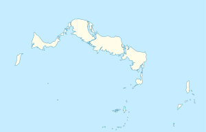
Map of the Turks and Caicos Islands
The Caicos Islands ( English Caicos Islands ) are a group of islands in the Atlantic Ocean about 200 kilometers north of the island of Hispaniola . Together with the Turks Islands , which are almost 40 kilometers southeast, they form the British overseas territory of the Turks and Caicos Islands .
The archipelago includes over 30 islands, the main island Providenciales as well as West Caicos , North Caicos , Middle Caicos , East Caicos and South Caicos are among the well-known .
Islands f1 OSM WikiMap
This incomplete list contains a selection of the Caicos Islands (pre-sorted from west to east):
Island name
annotation
Coordinates
Area
Residents
West Caicos
! 427.5469445521.6658335 21 ° 40 ′ N , 072 ° 27 ′ W. 21.665833333333 -72.453055555556
23.3
0000! -
Providenciales
! 427.7175005521.7822225 21 ° 47 ′ N , 072 ° 17 ′ W. 21.782222222222 -72.2825
98
23769! 23,769 a)
Mangrove Cay
! 427.8583335521.8236115 21 ° 49 ′ N , 072 ° 09 ′ W. 21.823611111111 -72.141666666667
...
0000! -
Little Water Cay
Iguana Island
! 427.8530565521.8358335 21 ° 50 ′ N , 072 ° 09 ′ W. 21.835833333333 -72.146944444444
...
0000! -
Donna Cay
! 427.8641675521.8313895 21 ° 50 ′ N , 072 ° 08 ′ W. 21.831388888889 -72.135833333333
...
0000! -
Water Cay
! 427.8772225521.8505565 21 ° 51 ′ N , 072 ° 07 ′ W. 21.850555555556 -72.122777777778
2.5
0000! -
Pine Cay
! 427.9055565521.8750005 21 ° 53 ′ N , 072 ° 06 ′ W. 21,875 -72.094444444444
2.8
0001! *)
Stubbs Cay
! 427.9219445521.8822225 21 ° 53 ′ N , 072 ° 05 ′ W. 21.882222222222 -72.078055555556
0.37
0000! -
Fort George Cay
! 427.9111115521.8916675 21 ° 54 ′ N , 072 ° 05 ′ W. 21.891666666667 -72.088888888889
0.3
0000! -
Dellis Cay
! 427.9263895521.8980565 21 ° 54 ' N , 072 ° 04' W 21.898055555556 -72.073611111111
2.3
0000! -
Parrot Cay
! 427.9394445521.9205565 21 ° 55 ′ N , 072 ° 04 ′ W. 21.920555555556 -72.060555555556
10
0131! 131
North Caicos
! 428.0538895521.8913895 21 ° 53 ′ N , 071 ° 57 ′ W. 21.891388888889 -71.946111111111
116.1
1312! 1.312
Middle Caicos
! 428.2655565521.7880565 21 ° 47 ′ N , 071 ° 44 ′ W. 21.788055555556 -71.734444444444
135.9
0168! 168
Bay Cay
! 428.1088895521.9277785 21 ° 56 ' N , 071 ° 53' W. 21.927777777778 -71.891111111111
...
0000! -
East Bay Cay
! 428.1233335521.8866675 21 ° 53 ' N , 071 ° 53' W. 21.886666666667 -71.876666666667
...
0000! -
Conch Cay (North)
! 428.1402785521.8536115 21 ° 51 ′ N , 071 ° 52 ′ W. 21.853611111111 -71.859722222222
...
0000! -
Highas Cay
! 428.1516675521.8675005 21 ° 52 ' N , 071 ° 51' W. 21.8675 -71.848333333333
...
0000! -
East Caicos
! 428.5019445521.7025005 21 ° 42 ′ N , 071 ° 30 ′ W. 21.7025 -71.498055555556
90
0000! -
South Caicos
! 428.4822225521.5094445 21 ° 31 ' N , 071 ° 31' W. 21.509444444444 -71.517777777778
24.1
1139! 1.139 b)
Long Cay
! 428.4413895521.4661115 21 ° 28 ′ N , 071 ° 34 ′ W. 21.466111111111 -71.558611111111
0.9
0000! -
Middleton Cay
! 428.4177785521.4841675 21 ° 29 ′ N , 071 ° 35 ′ W. 21.484166666667 -71.582222222222
...
0000! -
Conch Cay (South)
! 428.4188895521.4716675 21 ° 28 ′ N , 071 ° 35 ′ W. 21.471666666667 -71.581111111111
...
0000! -
Little Ambergris Cay
! 428.3108335521.2955565 21 ° 18 ′ N , 071 ° 41 ′ W. 21.295555555556 -71.689166666667
6.6
0000! -
Big Ambergris Cay
! 428.3663895521.3044445 21 ° 18 ′ N , 071 ° 38 ′ W. 21.304444444444 -71.633611111111
4.3
0001! *)
Breaker rock
! 428.3810565521.2358335 21 ° 14 ′ N , 071 ° 37 ′ W. 21.235833333333 -71.618944444444
0.006
0000! -
Bush Cay
! 428.3705285521.1986675 21 ° 12 ′ N , 071 ° 38 ′ W. 21.198666666667 -71.629472222222
0.08
0000! -
Shot Cay
! 428.2941945521.1788895 21 ° 11 ′ N , 071 ° 42 ′ W. 21.178888888889 -71.705805555556
0.013
0000! -
Indian Cay
! 428.2122505521.1880005 21 ° 11 ′ N , 071 ° 47 ′ W. 21.188 -71.78775
0.05
0000! -
White Cay
! 428.2005565521.1848065 21 ° 11 ′ N , 071 ° 48 ′ W. 21.184805555556 -71.799444444444
0.04
0000! -
West Sand Spit
almost flooded
! 427.8605835521.3932505 21 ° 24 ′ N , 072 ° 08 ′ W. 21.39325 -72.139416666667
...
0000! -
French Cay
! 427.7994445521.5069445 21 ° 30 ′ N , 072 ° 12 ′ W. 21.506944444444 -72.200555555556
0.089
0000! -
*) The population of Pine Cay and Big Ambergris Cay are not collected separately, but are added to Providenciales and South Caicos, respectively.
a) This also includes the residents of Pine Cay.
b) This includes the residents of Big Ambergris Cay.
The islands or cays in the southeast of the Caicos Bank, from Bush Cay to White Cay, are part of the Seal Cays Wildlife Sanctuary .
literature HE Sadler, Marjorie Sadler, Karen Collins: Turks Islands Landfall. A History of the Turks & Caicos Islands . Marjorie E. Sadler, Grand Turk - Turks and Caicos Islands 1997, ISBN 976-8138-62-9 .
Individual evidence
↑ 2012 Population and Housing Census - Preliminary Report. caribbeanelections.com. KnowledgeWalk Institute, p. 26 , accessed on September 24, 2019 .
<img src="https://de.wikipedia.org//de.wikipedia.org/wiki/Special:CentralAutoLogin/start?type=1x1" alt="" title="" width="1" height="1" style="border: none; position: absolute;">
![]() Map with all coordinates: OSM | WikiMap
Map with all coordinates: OSM | WikiMap


