Turks Islands
| Turks Islands | ||
|---|---|---|
|
Satellite image of the Turks Islands (excluding Big Sand Cay further south ) |
||
| Waters | Atlantic Ocean | |
| archipelago | Lucay Islands | |
| Geographical location | 21 ° 24 ′ N , 71 ° 9 ′ W | |
|
|
||
| Number of islands | 11 | |
| Main island | Grand Turk | |
| Total land area | 26.8 km² | |
| Residents | 4939 | |
| Map of the Turks and Caicos Islands | ||
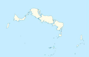
The Turks Islands ( English Turks Islands ) are a small group of islands in the Atlantic Ocean 142 kilometers north of the island of Hispaniola . The archipelago is separated from the Caicos Islands, 40 kilometers northwest , by the Turks Island Passage, and from the Mouchoir Bank in the east by the deep, 26 kilometers wide Mouchoir Passage . Together with the Caicos Islands, it forms the British overseas territory of the Turks and Caicos Islands .
The Turks are mostly small, flat and sparsely vegetated sand islands. The chain of islands , to which around a dozen islets belong, stretches from north to south over 38.2 kilometers as the crow flies .
Except for Salt Cay and Grand Turk , on which Cockburn Town , capital of the Turks and Caicos Islands, is located, the Turks Islands are uninhabited.
List of Turks Islands
Indisputable islands
![]() Map with all coordinates: OSM | WikiMap
Map with all coordinates: OSM | WikiMap
Overview of the islands (pre-sorted from north to south):
| Island name | annotation | Coordinates | Area km² (approx.) |
Residents 2012 |
|---|---|---|---|---|
| Grand Turk | 21 ° 28 ′ 04.0 ″ N , 071 ° 08 ′ 23.0 ″ W. | 17.39 | 4,831 | |
| The Island | Inland island | 21 ° 28 ′ 15.0 ″ N , 071 ° 08 ′ 26.0 ″ W. | 0.06 | - |
| Gibbs Cay | 21 ° 26 ′ 30.0 ″ N , 071 ° 06 ′ 44.0 ″ W. | 0.06 | - | |
| Round Cay | 21 ° 26 '12.8 " N , 071 ° 06'29.0" W. | 0.01 | - | |
| Long Cay | Pelican Cay | 21 ° 24 ′ 52.0 ″ N , 071 ° 05 ′ 55.0 ″ W. | 0.19 | - |
| Penniston Cay | 21 ° 22 ′ 31.0 ″ N , 071 ° 07 ′ 17.0 ″ W. | 0.03 | - | |
| Pear Cay | Bird Island | 21 ° 22 ′ 23.0 ″ N , 071 ° 05 ′ 22.0 ″ W. | 0.11 | - |
| Cotton Cay | 21 ° 21 ′ 49.0 ″ N , 071 ° 09 ′ 09.0 ″ W. | 1.13 | - | |
| East Cay | Pinzon Cay / Breeches Island | 21 ° 21 '20.0 " N , 071 ° 05' 17.0" W. | 0.46 | - |
| Toney Rock | Centry | 21 ° 20 ′ 18.5 ″ N , 071 ° 05 ′ 11.7 ″ W. | 0.005 | - |
| Salt Cay | 21 ° 19 ′ 46.0 ″ N , 071 ° 12 ′ 05.0 ″ W. | 6.47 | 108 | |
| Whale Island | 21 ° 20 '01.8 " N , 071 ° 11' 14.2" W. | 0.003 | - | |
| Big Sand Cay | 21 ° 11 ′ 33.0 ″ N , 071 ° 14 ′ 55.0 ″ W. | 0.58 | - |
Disputed islands
Little Sand Cay between the southern tip of Grand Turk Island and Cotton Cay ( 21 ° 23 ′ 44.4 ″ N , 071 ° 09 ′ 26.5 ″ W ) measures only a few hundred square meters, changes its size and location over time and can at Spring tide be completely flooded.
Endymion Rock is believed to be a coral reef in the south of the Turk Bank ( 21 ° 07 ′ N , 071 ° 18 ′ W ) that reaches only a few meters below the water surface . According to one source, it is a shoal where the HMS Endymion sank in 1790 and gave the place its name. Endymion Rock is marked as an island on other maps .
literature
- HE Sadler, Marjorie Sadler, Karen Collins: Turks Islands Landfall: A History of the Turks & Caicos Islands . 1997, ISBN 976-8138-62-9 .
Individual evidence
- ↑ 2012 Population and Housing Census - Preliminary Report. (PDF; 1.69 MB) In: caribbeanelections.com. KnowledgeWalk Institute, p. 26 , accessed September 25, 2019 .
- ↑ Visit Turks & Caicos Islands: Other Cays of the Turks and Caicos Islands : This patch of ground is simply a small round sand bar. Found two miles south of Grand Turk, Little Sand Cay changes size and location over time and can be totally submerged during a spring tide.
- ↑ Donald Keith: Turks & Caicos: Endymion Rock. Expedition report. Waitt Institute, archived from the original on October 8, 2018 ; accessed on September 25, 2019 (English).
- ↑ CIA Map 1976


