North Caicos
| North Caicos | ||
|---|---|---|
| Position of the island | ||
| Waters | Atlantic Ocean | |
| Archipelago | Caicos Islands | |
| Geographical location | 21 ° 53 ′ N , 71 ° 57 ′ W | |
|
|
||
| length | 21.8 km | |
| width | 8.56 km | |
| surface | 116.4 km² | |
| Highest elevation | 20 m | |
| Residents | 1312 (2012) 11 inhabitants / km² |
|
| main place | Bottle Creek | |
North Caicos is the second largest island of the Atlantic Ocean located Caicos Islands and is part of the British overseas territory of the Turks and Caicos Islands .
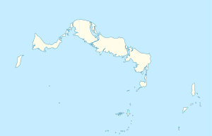
It is only separated from the neighboring islands of Parrot Cay and Middle Caicos by narrow inlets. The land area of North Caicos is 116 km². The island is divided by Flamingo Lake , a 5 km long brackish water lake that is now open to the sea at high tide , into two peninsulas of almost the same size , which are then only connected by an isthmus in the north of just under one kilometer .
The main town Bottle Creek and North Caicos Airport are on the east coast of the southern peninsula . On the northern peninsula are the villages of Whitby / Kew and Sandy Point. Today (as of 2012) 1312 people live on North Caicos, which is slightly less than in the previous census in 2001 (1347 inhabitants).
literature
- HE Sadler, Marjorie Sadler, Karen Collins: Turks Islands Landfall. A History of the Turks & Caicos Islands . Marjorie E. Sadler, Grand Turk - Turks and Caicos Islands 1997, ISBN 976-8138-62-9 .
Web links
- North Caicos and Middle Caicos Tourism. In: visittci.com. Visit Turks and Caicos Islands Limited.
Individual evidence
- ^ Physical Characteristics. Land areas of the Turks and Caicos Islands. Department of Economic Planning and Statistics, Government of Turks and Caicos, archived from the original on March 25, 2009 ; accessed on December 4, 2018 .
- ↑ 2012 Population and Housing Census - Preliminary Report. (PDF; 1.69 MB) In: caribbeanelections.com. KnowledgeWalk Institute, p. 26 , accessed December 4, 2018 .

