Camden, Arkansas
|
|
This article was on the basis of substantive defects quality assurance side of the project USA entered. Help bring the quality of this article to an acceptable level and take part in the discussion ! A closer description on the resolving issues is missing. |
| Camden | |
|---|---|
 Downtown Camden |
|
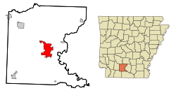
| Location in county and Arkansas | |
| Basic data | |
| Foundation : | December 11, 1844 |
| State : | United States |
| State : | Arkansas |
| County : | Ouachita County |
| Coordinates : | 33 ° 34 ′ N , 92 ° 50 ′ W |
| Time zone : | Central ( UTC − 6 / −5 ) |
| Residents : | 13,154 (as of: 2000) |
| Population density : | 308.8 inhabitants per km 2 |
| Area : | 42.8 km 2 (approx. 17 mi 2 ) of which 42.6 km 2 (approx. 16 mi 2 ) is land |
| Height : | 62 m |
| Postcodes : | 71701, 71711 |
| Area code : | +1 870 |
| FIPS : | 05-10720 |
| GNIS ID : | 0076505 |
| Website : | www.camden.gov |
Camden is a US city and county seat in Ouachita County in the US state of Arkansas . It has about 12,500 inhabitants (as of 2004). The urban area has a size of 42.6 km².
Camden is part of the Ark-La-Tex socio-economic region that includes parts of the states of Arkansas, Louisiana , Oklahoma, and Texas .
history
Historical objects
- The historically relevant Ben Laney Bridge is on US Route 79B .
Population development
| Population development | |||
|---|---|---|---|
| Census | Residents | ± in% | |
| 1850 | 894 | - | |
| 1860 | 2219 | 148.2% | |
| 1870 | 1612 | -27.4% | |
| 1880 | 1503 | -6.8% | |
| 1890 | 2571 | 71.1% | |
| 1900 | 2840 | 10.5% | |
| 1910 | 3995 | 40.7% | |
| 1920 | 3238 | -18.9% | |
| 1930 | 7273 | 124.6% | |
| 1940 | 8975 | 23.4% | |
| 1950 | 11,372 | 26.7% | |
| 1960 | 15,823 | 39.1% | |
| 1970 | 15,147 | -4.3% | |
| 1980 | 15,356 | 1.4% | |
| 1990 | 14,380 | -6.4% | |
| 2000 | 13,154 | -8.5% | |
| 1850-2000 | |||
sons and daughters of the town
- George Washington Hays (1863–1927), Governor of Arkansas
- Benjamin Travis Laney (1896–1977), governor of Arkansas
- Catherine Dorris Norrell (1901–1981), politician, member of the US House of Representatives
- David Pryor (born 1934), politician, governor of Arkansas
- Carl Burnett (* 1941), jazz musician
- Ne-Yo (born 1979), singer
Individual evidence
- ^ Extract from the Encyclopedia of Arkansas . Retrieved February 13, 2011
Web links
Commons : Camden, Arkansas - collection of pictures, videos, and audio files
- Website of the city of Camden (Engl.)
- City profile on arkansas.com (Engl.)

