Capitol Reef National Park
| Capitol Reef National Park | ||
|---|---|---|
| Golden Throne in Capitol Reef National Park | ||
|
|
||
| Location: | United States | |
| Next city: | Torrey (Utah) | |
| Surface: | 978.95 km² | |
| Founding: | 18th December 1971 | |
| Visitors: | 1,227,627 (2018) | |
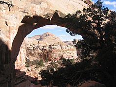
| Hickman Bridge | ||
The Capitol Reef National Park in Utah was established on December 18, 1971, after it had already been designated a National Monument on August 2, 1937 . The name comes from an area near the Fremont River that reminded the first pioneers of a reef. In the 19th century, Mormon settlers founded the place Fruita . The heart of the national park is the Waterpocket Fold , a geological formation over 150 km long that extends in a north-south direction. The originally horizontal layers of soil, which arose from sediments, were slightly inclined and bent when the Colorado Plateau rose . Today's 'fold' was created by erosion, which, like a fault, has distinctive dividing lines between the geological layers. There is a well-developed network of hiking trails in the park.
history
Already Indians of the Fremont culture lived along the Fremont River in 700 AD. They shared their territory with the Anasazi living in the south . The Fremont Indians were hunters and gatherers, and they also grew corn, beans, and pumpkins. For unknown reasons, the people disappeared around 1250 AD, leaving only rock paintings and incised drawings. Years later, nomadic Ute and Paiute Indians hunted in what is now the Capitol Reef National Park . At the end of the 19th century, the first pioneers and researchers began to penetrate the area of the Fremont River. Those who wanted to go into the valley had to take the Fremont Gorge at the time. This was a narrow and rocky route that went through the crevice. At one point on the route, a rock wall, called the pioneer register , the names of pioneers, settlers and miners can be read who moved through the gorge from 1871 onwards. Around 1900 the first place, Fruita, arose on the banks of the Fremont River. The settlers skillfully irrigated the fertile soil, making it possible to grow fruit. Fruita then became known for the quality of its fruit. The valley was often hit by floods, but they did not cause any great damage. In 1937 the area around the Fremont River became the Capitol Reef National Monument . After that, the farmers and their families gradually left Fruita.
Access
From Interstate 70 , Utah Highway 24 leads to the east entrance of the park.
Paths of the park
- Fremont River & Scenic Drive
- Burr Trail Road
- Cathedral Valley Loop
- Hickman Bridge Trail
Attractions
literature
- National Park Service: Capitol Reef National Park Guide German (German)
Web links
- National Park Service: Capitol Reef National Park (official site; English)
- US National Parks Net: Capitol Reef National Park (English)
- Hiking in the Capitol Reef National Park (German)
- Capitol Reef National Park (German)
- Report with pictures and background information about Capitol Reef (German)


