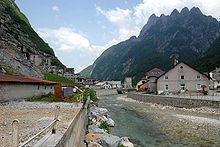
Raibl
Raibl ( Italian : Cave del Predil , Slovenian : Rabelj ) is a mining town in the Seebach Valley , 15 km south of Tarvisio in the Italian region of Friuli-Venezia Giulia . The place is part of the municipality of Tarvisio.
geography
The place lies at 900 m above sea level and gets its character from the lead mine, which was closed in 1991 . Until the end of the First World War , the place belonged to Carinthia like the entire Canal Valley and was predominantly German-speaking . In addition, Raibl had a minority of Slovenian residents from mining , who came to work from the Koritnica valley through the tunnel under the Predil pass. In 1918 Raibl fell to Italy . After the resettlement under Mussolini , the place is almost exclusively Italian-speaking. Cave del Predil is now a fraction of the municipality of Tarvisio and in 1968 still had 2,100 inhabitants. After the cessation of mining operations, the population sank rapidly, in 1999 only 450 people lived in the village.
Road connections and tourism
Raibl is the starting point of the road over the Predilpass to Bovec (German: Flitsch) in the Slovenian Sočatal as well as over the Nevea saddle and the Raccolana valley to Chiusaforte . Raibl is the starting point for numerous mountain hikes in the western Julian Alps (Kaning area, Montasch and Wischberg groups). The local mountain is the 2122 m high Raibler Seekopf ( Cima di Lago ). To the south of the village is the cold, dark, mountain-framed Raibler See ( Lago del Predil ). Before the First World War, the Austrian Raibler Seefort stood roughly in the middle of the north-west bank and secured the imperial border that ran through the Seebach valley.
Raibl is connected to the Slovenian town of Gorni Log (German: Ober Breth) by a 5 km long tunnel that runs under the Predil Pass and through which the miners from Gorni Log used to drive to the Raibl mine for shifts. During the First World War it was also used to supply the Isonzo front under the name Kaiser-Franz-Josef- Hilfsstollen .
history
The foundation and the name of this place go back to the year 1320 in the Bamberg time ( Archdiocese of Bamberg ), when Frederick the Fair gave a group of miners permission to dig for minerals in this area. Among those people there was a man named Rabl who owned properties there. It is believed that the settlement is named after him Raibl .
Buildings
In the middle of the mine is the old, almost dilapidated, from Bamberg Bishop Count Georg III. Church of St. Anna, donated in 1550. In 1969 a new church was built nearby. At the western exit of the village is the military cemetery built for the dead of the First World War. On May 18, 1809, Emperor Ferdinand I erected the lion monument on the Predil Pass to defend the fort against the French by Captain Johann Hermann von Hermansdorf and his crew.
Accident of 1910
On January 8, 1910, parts of a mine collapsed in the mine. This opened a crater on the surface of the earth, in which the Raibl hospital literally disappeared. Of eight people who were in the building, only a 14-year-old survived the accident.
Sons and daughters of the place
- Giuseppe Wulz (1843–1918), photographer.
Sightseeing
A mining museum and a military museum can be visited in the village.
geology
With Raibler layers refers to a particular form of rock layering, a technical term from the geology (see, for. Example Puez-Geisler ).
literature
- Karl Migglautsch and Ingomar Pust: The Canal Valley and its History , published by Kanaltaler Kulturverein, Klagenfurt 1995; ISBN 3-901088-04-0
- G. Pilgram , W Berger, G. Maurer: Carinthia. Down through. A hiking-travel-reading book. Carinthia Verlag, 2006 ISBN 3-85378-594-8
- G. Pilgram , W. Berger, W. Koroschitz, A. Pilgram-Ribitsch, The last valleys. Hiking and stopping off in Friuli. Drava Verlag, Klagenfurt 2008 ISBN 978-3-85435-532-8
- Franz Posepny: The lead and calamine ore deposits of Raibl in Carinthia . in: Yearbook of the Imperial and Royal Geological Institute, vol. 23, Vienna 1873, pp. 317–424 ( digitized version ; PDF; 7.8 MB)
- Marko Simić: On the trail of the Isonzo front , Mohorjeva Hermagoras, Klagenfurt-Laibach-Wien 2004; ISBN 3-85013-884-4
- Georg Lux, Helmuth Weichselbraun: Derelict & Forgotten - Lost Places in the Alps-Adriatic Region . Styria Verlag, Vienna / Graz / Klagenfurt 2017, ISBN 978-3-222-13551-4
Web links
Coordinates: 46 ° 27 ' N , 13 ° 34' E
Individual evidence
- ↑ Georg Lux, Helmuth Weichselbraun: Forfeited & Forgotten - Lost Places in the Alps-Adriatic Region . 2nd Edition. Styria, Vienna / Graz / Klagenfurt 2017, ISBN 978-3-222-13551-4 , pp. 20-27 .


