
Chauffayer
| Chauffayer | ||
|---|---|---|

|
|
|
| local community | Aubessagne | |
| region | Provence-Alpes-Cote d'Azur | |
| Department | Hautes-Alpes | |
| Arrondissement | Gap | |
| Coordinates | 44 ° 45 ′ N , 6 ° 1 ′ E | |
| Post Code | 05800 | |
| Former INSEE code | 05039 | |
| Incorporation | 1st January 2018 | |

Chauffayer ( Occitan : Chaufaier ) is a former French commune with the last 392 inhabitants (at January 1, 2014) in the Hautes-Alpes in the region of Provence-Alpes-Cote d'Azur . It belonged to the Gap arrondissement and the canton of Saint-Bonnet-en-Champsaur .
With effect from January 1, 2018, the former municipalities of Chauffayer , Saint-Eusèbe-en-Champsaur and Les Costes were merged to form Commune nouvelle Aubessagne . The status of a Commune déléguée was not granted to them in the new municipality . The administrative headquarters are in Chauffayer.
location
It was bordered by Saint-Firmin to the north, Saint-Jacques-en-Valgodemard and Les Costes to the east, Saint-Eusèbe-en-Champsaur to the south, Le Noyer to the southwest and Le Glaizil to the west .
history
It is known that in 1373 the village was called "Chalfanerium".
Population development
| year | 1962 | 1968 | 1975 | 1982 | 1990 | 1999 | 2008 | 2012 |
|---|---|---|---|---|---|---|---|---|
| Residents | 496 | 504 | 528 | 402 | 363 | 334 | 385 | 391 |
Attractions
- Sainte-Anne pastoral church
- Chapel of Sainte-Anne
- Château des Herbeys castle

Canal-des-Herbeys
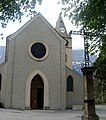
19th century Church of Sainte-Anne

Château des Herbeys


