Chucuito district
| Chucuito district | |
|---|---|
 The Chucuito District is located in the northeast of the Puno Province (marked in red) |
|
| Basic data | |
| Country | Peru |
| region | Puno |
| province | Puno |
| Seat | Chucuito |
| surface | 121.2 km² |
| Residents | 7019 (2017) |
| density | 58 inhabitants per km² |
| ISO 3166-2 | PE-PUN |
| politics | |
| Alcalde District | Justo Apaza Delgado (2019-2022) |
| View over Chucuito to Lake Titicaca | |
Coordinates: 15 ° 54 ′ S , 69 ° 53 ′ W
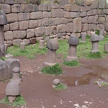
The Chucuito District is located in the Puno Province in the Puno Region in southern Peru . The district has an area of 121.18 km². The 2017 census counted 7,019 inhabitants. In 1993 the population was 9,833, in 2007 7,913. The administrative seat of the district is the 3871 m high village of Chucuito with 1135 inhabitants (as of 2017). Chucuito is located on the west bank of Lake Titicaca , 16 km east-southeast of the provincial and regional capital Puno . In the main town of Chucuito is the archaeological site of Inka Uyu.
Geographical location
The Chucuito district is located in the Altiplano on the west bank of Lake Titicaca in the northeast of the Puno province. The distant northern part of the Chucuito peninsula also belongs to the district area.
The district of Chucuito borders in the southeast on the district Platería , in the southwest on the district Pichacani and in the west on the district Puno .
Individual evidence
- ↑ a b PERU: Region Puno - Provinces and Districts . www.citypopulation.de. Retrieved April 21, 2020.


