
Chukha
| Chukha district | |
|---|---|
  |
|
| Basic data | |
| Country | Bhutan |
| Capital | Phuentsholing |
| surface | 1802 km² |
| Residents | 84,206 (2012) |
| density | 47 inhabitants per km² |
| ISO 3166-2 | BT-12 |
 |
|
Coordinates: 27 ° 0 ' N , 89 ° 30' E
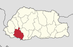
Chukha ( ཆུ་ ཁ་ རྫོང་ ཁག་ , formerly: Chhukha) is one of the 20 districts ( Dzongkhag ) of Bhutan with an area of 1802 km². About 84,206 people live in this district (2012).
Chukha, established in April 1987, is considered to be the economically most important district in Bhutan. The largest city of Chukha is Phuentsholing with about 23,000 inhabitants .
The district of Chukha is in turn divided into 11 Gewogs :
- Bhalujhora Weighed
- Bjacho Weighed
- Bongo Weighed
- Chapcha Weighed
- Dala Weighed
- Dungna Weighed
- Successful Weighed
- Getena Weighed
- Logchina Weighed
- Metakha Weighed
- Phuentsholing Weighed
Web links
Commons : Chukha District - Collection of images, videos and audio files
- Official website (English)

Bumthang | Chukha | Dagana | Gasa | Haa | Lhuntse | Mongar | Paro | Pemagatshel | Punakha | Samdrup Jongkhar | Velvet | Sarpang | Thimphu | Trashigang | Trashiyangtse | Trongsa | Tsirang | Wangdue Phodrang | Zhemgang