
Sarpang (district)
| Sarpang District | |
|---|---|
  |
|
| Basic data | |
| Country | Bhutan |
| Capital | Sarpang |
| surface | 1,945.5 km² |
| Residents | 43,915 (2012) |
| density | 23 inhabitants per km² |
| ISO 3166-2 | BT-31 |
Coordinates: 27 ° 0 ' N , 90 ° 24' E
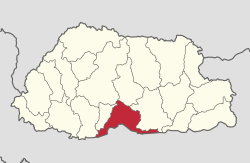
Sarpang ( གསར་ སྤང་ རྫོང་ ཁག་ ; also: Geylegphug, Gaylegphug, Gelephu (Sarbhang)) is one of the 20 districts ( dzongkhag ) of Bhutan . About 43,915 people (2013) live in this district. The Sarpang area covers 1945.5 km².
The capital of the district is Sarpang of the same name .
The Sarpang district is divided into 12 Gewogs :
- Chhudzom Weighed
- Chuzargang Weighed
- Dekiling Weighed
- Gakiling Weighed
- Gelephu Weighed
- Jigmechoeling Weighed
- Velvet Weighed
- Sershong Weighed
- Shompangkha Weighed
- Singye Weighed
- Taraythang Weighed
- Umling Weighed
Web links
Commons : Sarpang District - Collection of images, videos and audio files

Bumthang | Chukha | Dagana | Gasa | Haa | Lhuntse | Mongar | Paro | Pemagatshel | Punakha | Samdrup Jongkhar | Velvet | Sarpang | Thimphu | Trashigang | Trashiyangtse | Trongsa | Tsirang | Wangdue Phodrang | Zhemgang