
Gasa (district)
| Gasa district | |
|---|---|
  |
|
| Basic data | |
| Country | Bhutan |
| Capital | Gasa |
| surface | 4089 km² |
| Residents | 3326 |
| density | 0.8 inhabitants per km² |
| ISO 3166-2 | BT-GA |
 |
|
Coordinates: 27 ° 55 ' N , 89 ° 45' E
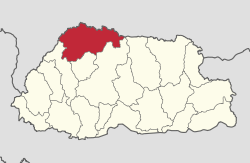
Gasa ( མགར་ ས་ རྫོང་ ཁག་ ) is one of the 20 districts ( dzongkhag ) of Bhutan . Gasa is the northernmost, largest in terms of area, as well as the least and most sparsely populated district of Bhutan. It is located on the border with Tibet in the ( dzongdey ) Central zone . Gasa was raised to an independent district in 1992, before that Gasa was under the administration of Punakha .
The population of the district is 3326. The area is 4089 km². The capital of the district is of the same name Gasa . The district of Gasa is divided into the main town Gasa and four Gewogs (with population):
- Gasa (402) (lies in the northeast of Goenkaatoe Gewog , but does not belong to this)
- Goenkhamae Gewog (906) (southwest)
- Goenkaatoe Gewog (166) (West)
- Laya Gewog (949) (northwest)
- Lunana Gewog (693) (East)
Web links
Individual evidence
- ↑ His Majesty The King graces Gasa Dzongkhag's silver jubilee celebrations. Bhutan Broadcasting Service , December 29, 2017, accessed February 17, 2018 .

Bumthang | Chukha | Dagana | Gasa | Haa | Lhuntse | Mongar | Paro | Pemagatshel | Punakha | Samdrup Jongkhar | Velvet | Sarpang | Thimphu | Trashigang | Trashiyangtse | Trongsa | Tsirang | Wangdue Phodrang | Zhemgang