
Dagana (district)
| Dagana District | |
|---|---|
  |
|
| Basic data | |
| Country | Bhutan |
| Capital | Dagana |
| surface | 1389 km² |
| Residents | 27,500 (2015) |
| density | 20 inhabitants per km² |
| ISO 3166-2 | BT-22 |
Coordinates: 27 ° 0 ' N , 89 ° 54' E
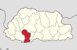
Dagana ( དར་ དཀར་ ན་ རྫོང་ ཁག་ ; also: Dhakana, Tagana or Daga) is one of the 20 districts ( dzongkhag ) of Bhutan . Around 27,500 people (2015) live in this district on an area of 1389 km².
The capital of the district is of the same name Dagana .
The district of Dagana is in turn divided into 14 Gewogs :
- Deorali Weighed
- Dorona Weighed
- Drujegang Weighed
- Gesarling Weighed
- Goshi Weighed
- Kana Weighed
- Khebisa Weighed
- Lajab Weighed
- Lhamoizingkha Weighed
- Nichula Weighed
- Tashiding Weighed
- Tsangkha Weighed
- Tsendagana Weighed
- Tseza Weighed
The Gewogs Deorali, Lhamoizingkha and Nichula were part of the Sarpang District until 2007 .
Web links
Commons : Dagana District - Collection of images, videos, and audio files

Bumthang | Chukha | Dagana | Gasa | Haa | Lhuntse | Mongar | Paro | Pemagatshel | Punakha | Samdrup Jongkhar | Velvet | Sarpang | Thimphu | Trashigang | Trashiyangtse | Trongsa | Tsirang | Wangdue Phodrang | Zhemgang