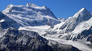
Grand Combin
| Grand Combin | ||
|---|---|---|
|
Grand Combin, right Combin de Corbassière |
||
| height | 4314 m above sea level M. | |
| location | Canton of Valais , Switzerland | |
| Mountains | Valais Alps | |
| Dominance | 26.4 km → Dent Blanche | |
| Notch height | 1517 m ↓ Fenêtre de Durand | |
| Coordinates | 589 008 / 86 994 | |
|
|
||
| First ascent | July 20, 1857 by Benjamin and Maurice Felley, Jouvence Bruchez | |
The Grand Combin is a heavily glaciated mountain massif in the western Valais Alps , in the southwest of the canton of Valais , Switzerland . It is one of the highest mountain peaks in the Alps and consists of three main peaks, the Combin de Valsorey ( 4183 m above sea level ), Combin de Grafeneire ( 4314 m above sea level ) and Combin de la Tsessette ( 4134 m above sea level ) from west to east above sea level ).
geography
The Grand Combin Group is a massif that stretches to the west from the Val d'Entremont and the Great Saint Bernard Pass , to the north and east from the Val de Bagnes with the Lac de Mauvoisin reservoir , to the southeast from the Saumpass Fenêtre de Durand and in the south of the Val d'Ollomont, belonging to the Aosta Valley , is delimited.
The eastern flank of the Combin de la Tsessette drops very steeply over 1200 m to the Glacier de la Tsessette, a 2 km long glacier above the Mauvoisin reservoir . The Glacier du Sonadon and Glacier du Croissant extend to the south. The latter, a hanging glacier, unites with the 5 km long valley glacier Glacier du Mont Durand, whose water also feeds the Mauvoisin reservoir. The Glacier de Corbassière extends to the north of the Grand Combin .
In addition to the main peaks, this massif also includes the Petit Combin ( 3663 m above sea level ) and the Combin de Corbassière ( 3716 m above sea level ) west of the Corbassière glacier, as well as the Tournelon Blanc ( 3702 m above sea level ) east of it . The border between Italy and Italy runs over the southern foothills of the Grand Combin ( Mont Vélan , 3727 m above sea level ; Grande Tête de By, 3587 m above sea level ; Mont Avril, 3347 m above sea level ; all also glaciated) Switzerland .
geology
Geologically, the Grand Combin Massif belongs to the Pennine Nappes. The crystalline rocks of the Penninic were folded under high pressure during the formation of the Alps. Therefore the massif consists mainly of gneiss .
Routes
The Gneiss de Grand Combin is predominantly flat and brittle, the rock flanks are dangerous for falling rocks. The hanging glaciers threaten with Séracs ready to fall . All routes are therefore not free from objective dangers.
The normal route leads from the to 3030 m above sea level. M. on the west flank Cabane de Valsorey of the Swiss Alpine Club (SAC) over the NW flank to the summit of the Combin de Grafeneire. An alternative rise is via the SW edge. In between lies the west ridge (Meitin ridge, starting point also Cabane de Valsorey).
From the Italian side the ascent via the refuge Rifugio Franco Chiarella all'Amianthe . From the Rifugio Chiarella all'Amianthe there is an alternative to the SE ridge to the Combin de Grafeneire.
The Grand Combin is also climbed on skis in winter via the so-called Corridor and is a highlight of the Haute Route from Chamonix to Zermatt, which lasts several days .
The Petit Combin, the Combin de Corbassiere and the Grand Combin can be hiked as part of a multi-day trekking tour "Tour des Combins".
Ascent history
On August 14, 1851, Gottlieb Samuel Studer was the first to climb the Combin de Corbassière (3716 m). In 1857 the Combin de la Tsessette was founded by the Englishman William Mathews , on July 30, 1859 the Combin de Grafeneire by Charles Joseph Sainte-Claire Deville (together with Daniel, Emmanuel and Gaspard Balleys and Basile Dorsaz), on August 15, 1861 the Mont Avril (3347 m) by the Englishman F. Buxton, on July 6, 1867 the Tournelon Blanc (3702 m) by Hoffmann-Merian and on September 16, 1872 the Combin de Valsoray from the south side for the first time by JH Isler and J. Gillioz overcome. The Cabane de Panossière , built in 1881 by the Swiss Alpine Club on the eastern edge of the Corbassière glacier at 2770 m , made tours in this area much easier.
literature
- Helmut Dumler, Willi P. Burkhardt: Four-thousanders in the Alps. 12th, updated edition. Bergverlag Rother, Munich 2001, ISBN 3-7633-7427-2 .
Web links
- Grand Combin de Grafeneire at 4000m - the four-thousanders of the Alps
- Grand Combin on Peakbagger.com (English)
- Grand Combin on the ETHorama platform
- Video impressions Grand Combin
Remarks
- ↑ Video Tour des Combins (online)
- ↑ Grand Combin . In: Meyers Konversations-Lexikon . 4th edition. Volume 4, Verlag des Bibliographisches Institut, Leipzig / Vienna 1885–1892, p. 225.


