Copperbelt (Province)
| Copperbelt Province Copperbelt
|
|
|---|---|
| Basic data | |
| Country | Zambia |
| Capital | Ndola |
| surface | 31,328 km² |
| Residents | 2,480,700 (2017) |
| density | 79 inhabitants per km² |
| ISO 3166-2 | ZM-08 |
| Website | www.cbt.gov.zm (English) |
Coordinates: 13 ° 0 ′ S , 28 ° 0 ′ E
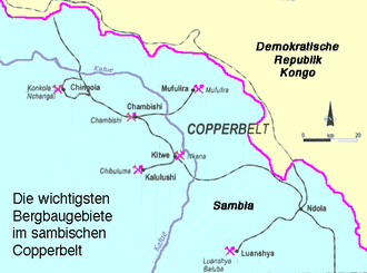
The province of Copperbelt (German Copperbelt ; English Copperbelt Province ) is a province in Zambia . It is best known for its copper mining . The actual Copperbelt extends into the Democratic Republic of the Congo .
Its capital is Ndola , further cities Kitwe , Chingola , Nchanga , Mufulira , Luanshya , Kalulushi , Chililabombwe and Chambishi . They are all shaped by the coal and steel industry (mines or smelters). The purely rural districts of Lufwanyama, Masaiti and Mpongwe are located south of and outside the actual Copperbelt. The Copperbelt Province has 2,480,700 inhabitants (2017 estimate) and covers 31,328 km².
Culture
The influx of African miners and ironworkers from over 70 language groups since the 1940s led to the fact that the language of the most brainy immigrant group, the Chi Bemba , became a “ lingua franca ” of the workforce there, partly also creolized ( ChiKoppabeluti ).
New customs such as the Kalela dance also emerged .
Mining
After independence, Zambia acquired 60% of the shares in the national copper mining and smelting through the state-owned Zambia Consolidated Copper Mines (ZCCM) . The employment of Zambians was forced, but ZCCM could not pay them wages and salaries of the whites. Through the CIPEC , to which four large African and Latin American copper states came together in 1967, the Zambian government tried to have a say in the price structure on the world market, like OPEC for oil. That failed. When copper prices began to fall in the 1970s, the government tried to make up for the bear market with loans, but in the 1980s had to allow the World Bank and the IMF to dictate harsh conditions , primarily affecting privatization and the tax system.
The fall in copper prices on the world market from the 1970s and their lowest point in the 1990s caused deep social upheavals in the Copperbelt.
The Zambian government tried to pass the debt on to the new owners, primarily through privatization. This opened a downward spiral. Over half of the jobs were lost. Luanshya became an example of this. Infrastructure fell into disrepair and construction came to a standstill. Illegal settlements formed in the surrounding forests, on disused mining areas and on contaminated spoil heaps. Many people lived on subsistence again . The informal sectors expanded all over the copper belt. The number of people formally employed in mining was 34,966 in 2001.
Since 2005 the tide has turned a bit. The number of those formally employed in mining rose to 51,000 in 2006. The cobalt market is growing by four percent a year. The prices are high. But cobalt makes up hardly a tenth of the copper production of which it is a by-product.
Floors
The soils in the Copperbelt, the Zambian plateau, are relatively uniform over thousands of square kilometers. They are red, yellowish brown and gray, which is related to the content of iron oxides . They are weathering products of gneiss . Soil fertility varies widely. The soils in Lufwanyama are not very productive, unlike the soils in Masaiti and Mpongwe. The other districts are little influenced by agriculture outside of subsistence.
Districts
literature
- Lars Clausen : Industrialization in Black Africa. A sociological lot study of two large companies in Zambia. Bertelsmann, Bielefeld 1968.
Web links
- Mines in the Copperbelt Geographic Institute of the University of Aachen
- Periurban Farming in the Copperbelt Province (English; PDF; 104 kB)


