Cordillera de Mochara
| Cordillera de Mochara | ||
|---|---|---|
| location | Bolivia | |
| part of | To the | |
|
|
||
| Coordinates | 21 ° 24 ′ S , 65 ° 24 ′ W | |
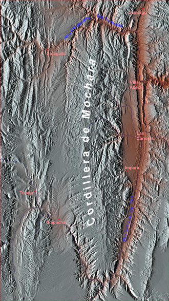
The Cordillera de Mochara (also: Serranía de Mochará ) is a high mountain landscape in the southern part of the Bolivian Andes . The mountain ridge has a length of about 120 kilometers and an average width of 20 kilometers.
The Cordillera Mochara is a north-south mountain range in the southwest region of the Bolivian department of Chuquisaca . The mountain range is bounded to the south and east by the Río San Juan del Oro , to the northeast and north by the Río Tumusla , to the northwest by the Río Cotagaita , and to the west by the Río Mochara , it forms the southern continuation of the Bolivian Cordillera Central and the Cordillera de Tajsara o Tarachaca .
The highest point of the Cordillera has a height of 4356 m , most of the mountain ridges only reach heights of about 3500 m. Directly north of this summit, the ridge is crossed by the north-south running highway Ruta 20 , which leads from Hornillos on Ruta 14 in the west to Las Carreras in the east, where it meets Ruta 1 .
The Cordillera region is almost uninhabited; all larger towns are located in the river valley of the Río San Juan del Oro on the eastern edge of the Cordillera. Administratively, the northern part of the Cordillera belongs to the administrative district ( Bolivian : Municipio ) Municipio Camargo in the province of Nor Cinti , the central part to the Municipio Villa Abecia and the Municipio Las Carreras in the Province of Sud Cinti , and the southern part to the Municipio Tupiza in the Province Sur Chichas in the Potosí department .

