Curacaví
| Curacaví | ||
|---|---|---|
|
Coordinates: 33 ° 24 ′ S , 71 ° 8 ′ W Curacaví on the map of Chile
|
||
| Basic data | ||
| Country | Chile | |
| region | Metropolitan Region | |
| Residents | 24,298 (2002) | |
| City insignia | ||
| Detailed data | ||
| surface | 693 km 2 | |
| Population density | 35 people / km 2 | |
| Waters | Estero Puangue | |
| Post Code | 9630000 | |
| prefix | +56 2 | |
| Time zone | UTC −4 | |
| City Presidency | Leonardo Bravo Gomez (July to December 2012) |
|
| Website | ||
Curacaví is a small town in the Región Metropolitana in the Melipilla Province in Chile . It has 24,298 inhabitants, of which almost 2/3 live in the urban area and about 1/3 in the rural area (status: 2002).
Geography and climate
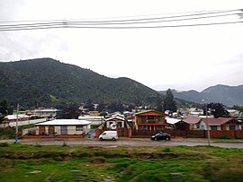
Curacaví is located about 60 km west of Santiago in the valley of the Puangue river, embedded between the steeply rising mountains of the coastal cordillera, which in this zone separates the higher valley basin of the capital Santiago from the coastal region of the port city of Valparaíso . The Ruta 68 , one of the two highways that connects Santiago with the Pacific coast, runs through the town . The mountains and the river are the dominant geological elements. So - apart from the road that follows the river to Melipilla - Curacaví can only be reached via mountain passes or, more conveniently, through the tunnels of the motorway.
Curacaví has a mild Mediterranean climate with a longer dry season and a rainy winter. From a biogeographical point of view, the community is located in the hardwood ecoregion . Quillaja , liter trees ( sumac family ) and boldo can be found scattered on the mountain slopes between their feet up to half the height, between 300 m and 800 m . An important factor in connection with the ecoregion is the occurrence of numerous rodents such as short-tailed chinchillas , brown rats , cururo ( turtle rats ), pygmy rice rats , as well as hares and rabbits .
The community area is approximately 693 km².
history
Early settlements
It is believed that as early as the pre-ceramics period of the Chilean central region, i.e. before about 1500 BC BC , also the Puanguetal was settled. Because the Piedras Tacitas are said to come from this era, which are found in large numbers in central Chile and neighboring Argentina, and of which a considerable specimen can be seen in Curacaví. It is a very large stone that was probably used as a community mortar and has corresponding cavities that are said to have been used to produce vegetable dyes for dyeing wool or painting ceramics.
The Puanguetal in the area of Curacaví was definitely settled around 1000 AD . In 1975, a burial ground was discovered in the neighboring community of María Pinto and partially excavated. In addition to the bones of numerous people, ceramics and stone artifacts were also found as grave goods. By 14 C dating , the year of death of a deceased could be determined to be 990 ± 80 AD. Ceramic finds in the municipality, for example in the Hacienda Curacaví and in Fundo Lolenco, prove the existence of other settlements. The influence of the Inca , who incorporated the central Chilean region into their domain from the middle of the 15th century , could also be seen in some ceramics .
The Spaniards are coming
The second Spanish invasion ( Conquista ) in what is now Chile, led by Pedro de Valdivia , reached the central region from 1540. At that time, several groups of indigenous people lived scattered all over the valley of the Puangue. Knowledge of these people comes solely from records of the colonial administration and contemporary reports. The Spaniards generally referred to the indigenous people in the valley of the Puangue as Picones , but differentiated the individual groups by the names of their clan chiefs, who were dubbed Kazike . These had fields in demarcated areas, which, however, were not within a boundary, but rather scattered from each other. The plots were probably occasionally traded among themselves.
A settlement was in today's urban area, on the banks of the Puangue near the formerly so-called Cerro de las Brujas (Witches Mountain), a small isolated hill that is located at the eastern entrance to the town, between the motorway and today's cemetery. The Spanish called the settlement Tambo Viejo de Puangue , which means something like: old Inca rest and camp site on the Puangue. It is therefore assumed that an important route led through Curacaví at the time of the immediately preceding Inca rule.
It is known that corn and melons were grown and an irrigation system was in place. The local indigenous population also owned fields in an area called Pico , about 40 kilometers south near today's Melipilla on the Maipo River, to which they retired in dry years.
The land is distributed
The colonial occupation of the country is well documented. So it is understandable that a significant part of the history is concerned with which people received or acquired rights to land.
With the oldest known document, issued on October 4, 1550, Pedro de Valdivia handed over the three caciques Antequiles, Chamuvo and Catalangua together with the associated indigenous population in the Poagui Valley (today Puangue) as an encomienda ("Encomienda de Indios") to Juan Bautista de Pastes . Although this only gave him the right to dispose of the population, he also appropriated the land that belonged to the inhabitants and was cultivated by them. The principle of colonization was to displace the indigenous population from the well-developed and easy-to-use zones. Those who were not employed in agriculture were settled near mines, where they were needed as labor, until about 1580. Juan Bautista de Pastene had hemp and flax grown, which were used to produce blankets and ropes. In 1582, after his death, the exact date is unknown, the son Tomás de Pastene Seixas inherited the Encomienda Puangue in the second generation.
On February 13, 1583 he received it from the governor Martín Ruiz de Gamboa . the "Merced de Tierras" over 105 cuadras (one cuadra has about 7000 m²) in the settlement of Puangue and 105 cuadras in the settlement of Curacaví "Merced" means in this epoch that the land became the personal property of the rights holder. While the father legally administered the land only for the Spanish king, the son was the first owner according to today's legal conceptions. Thereupon this finally expelled the indigenous population from their land and settled them in Pomaire near Melipilla , with the approval of the governor and contrary to instructions of the viceroy Francisco de Toledo for the protection of the indigenous people.
On March 22, 1590 Tomás de Pastene sold the Estancia Curacaví to Capitán Luis Monte de Sotomayor, who left it to one of his eight sons after his death. In 1602, Ginés de Lillo was commissioned by the Cabildo of Santiago with a surveying project, a kind of inventory in which landowners had to submit their titles for a review and in which the land was at least roughly measured. On May 25, 1604, the Estancia Puangue was measured, which at that time was owned by an heir of Luis Monte de Sotomayor's father-in-law.
In 1621 Juan de la Guardia was the owner of the two "Merced" from Curacaví, each with 105 Cuadras and other lands in Cuyuncaví. (North of today's city center) and north along the Puangue. This completely encompassed the area of today's city and much more. Due to the economic importance of the central region of Chile, land allocations for the entire valley of the Puangue were completed by 1621
A church is established
While a colonial settlement was usually established by tracing its streets in the area in a square pattern and making a map for the king, nothing like this happened in Curacaví. The encomienda from 1550 to Juan Bautista de Pastene is therefore often seen as a substitute for the founding act. In 1583, land uses were defined for the first time, with which a distinction was made between where farming was allowed and where accommodation could be built. Later, the houses were concentrated along the thoroughfare. It was not until 1891 that the place received its own municipal administration, but at that time it had no Plaza de Armas.
economy
Curacaví is mainly characterized by gastronomy, agriculture, craft and trade. There is no industry. Many residents commute to neighboring Santiago to work.
gastronomy
The central location between the capital Santiago de Chile and the port city of Valparaíso has shaped Curacaví as a rest stop for travelers since colonization. The route between these cities is an important transit route, which today is called "Ruta 68". It has been accessible by carts since the end of the 18th century and has been expanded as a motorway since around 1992. Therefore, in Curacaví there are traditionally many restaurants along the route.
Agriculture
In the vicinity of Curacaví there are farms (apples, oranges, corn, lettuce, avocado , cloves as cut flowers , prickly pears , almonds ), cattle breeding (cattle, chickens) and dairy farming (milk, cheese, manjar ). The fruit in particular is an important export product that is also delivered to Germany. Curacaví is generally known for its Federweißer (" Chicha de Curacaví"), to which a Cueca song was dedicated, which is very popular in Chile. Today, however, there is no longer a single winery, but a few small backyard vineyards cater to everyone who comes by with chicha until they drop.
Craft
Another important product, the so-called "Dulces de Curacaví", is made in numerous pastry shops . These are sweet pastries in various shapes with lots of caramel cream (manjar), powdered sugar and meringue . In the distribution of sweet pastries, the old tradition of bringing the product to the customer directly on the roadside has been preserved, today that means: in the middle of the motorway, in the relatively slow-moving traffic at the toll station in neighboring Casablanca.
Attractions
museum
The Museo de la Vivienda Tradicional Rural Unifamiliar Chilena (Museum of Traditional Rural Single Family Dwellings ) is a remarkable institution, with a unique open-air exhibition in which authentic historical indigenous houses from different regions of Chile are shown. The museum is somewhat hidden behind the town hall and is accessible during general opening times. Address: 1305 Avenida Ambrosio O'Higgins.
Estero Puangue
Just before leaving the village to the west, Isabel Riquelme road leads to the Puangue River. It is paved for a distance of around 10 km (as of 2007) and runs along the river. In summer the river hardly carries any water, which then mostly flows underground. With an all-terrain vehicle you can cross the fords on the further route even in winter and get to Colliguay and from there to Quilpué. The entire zone is ideal for picnic trips and in some places for swimming. The northern slopes of the mountains are dotted with tree-sized cacti.
Piedra Tacita
About 2.5 kilometers across the Isabel Riquelme road along the Puangue River, there is a large stone on the bank with a horizontally aligned surface at the top with numerous artificial, round depressions. It is a Piedra Tacita , simply referred to as a Tacita stone in German, of which there are a number of other specimens on the river banks of the central region of Chile. So far, one can only speculate about the processing and purpose of these unusual stones. These are probably meeting places from pre-Columbian times. Whether they served a cult, whether they were used as mortars or whether the early residents of Curacaví passed the time with a game and with chicha remains a secret to this day. The latter provision is at least proven for the present, because the Tacita stone is located on the edge of the Estadio Municipal , an urban area on which the Media Luna is located for the annual rodeo and where the national holiday is celebrated on September 18 and 19 becomes.
Plaza de Armas
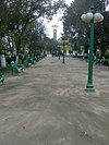
The Plaza de Armas , the central square of a colonial city, is somewhat untypical in Curacaví, not the center around which the city was laid out. The plaza was only laid out on the thoroughfare in the middle of the 20th century, relatively far away from the city administration buildings. In the shade of tall trees there is plenty of seating that invites you to linger and all sorts of stalls offering handicrafts.
The mountain pass roads
- Cuesta Lo Prado : This pass was created in the 18th century as part of the expansion of the connection between Santiago and Valparaíso as a route accessible by carts. Here you can still feel the original hardships and the adventure of a journey between the two cities. About 30 km west of Santiago on the highway to Valparaíso (Route 68), follow the signs. Today the ascent goes over a new, paved roadway with a view of the tollbooth of the motorway, the open-cast copper mine "Mina Pudahuel" and the research nuclear reactor in Lo Aguirre ( Centro de Estudios Nucleares Lo Aguirre ). Once at the top, you reach Curacaví and look over its rural areas of Pataguilla and Cerrillos to the neighboring community of María Pinto. The descent continues on the still unpaved road through Pataguilla to the intersection with Cruce Sta. Inés and from there via the district of Cerrillos back to the motorway. (In July 1829 Charles Darwin traveled in a three-horse carriage over this cuesta to Santiago.)
- Cuesta Vieja : The route has practically disappeared today. It is the first path used in colonial times, which can only be guessed at today. If you have made the ascent to Cuesta Lo Prado and look roughly to the northwest, you can see the zone through which the path from the pass to Curacaví led and which could be tackled on foot or on horseback.
- Cuesta Barriga
- Cuesta Zapata
If you don't want to use a car, depending on the time of day, you can reach Curacaví every 10 to 20 minutes from Santiago by bus from Terminal San Borja at the Estaciòn Central or from Terminal Pajaritos at the metro station of the same name. Coming from Melipilla about three times a day with a bus that goes to Casablanca and Valparaiso. Coming from the coast, it is advisable to take the fast buses to Santiago and get off on the motorway.
Personalities
- Enrique Madrid Osorio (1886–1945), Member of the Partido Liberal .
- Rosamel del Valle (1900-1965), poet.
- Juan Williams Rebolledo (1825–1910), naval commander.
See also
Web links
Individual evidence
- ↑ Ilustre Municipalidad de Curacaví (ed.): Plan Regulador Comunal Curacaví. Declaración de impacto ambiental - Anexo 1 Memoria explicativa PRC . 2007, p. 12 f . ( Conama - Gobierno de Chile - Sistema de Evaluación de Impacto Ambiental - Documents (PDF; 4.9 MB) [accessed on March 14, 2009]).
- ^ Ilustre Municipalidad de Curacaví. Ibid, p. 20.
- ↑ Jorge Rodríguez Ley: Declaración de impacto ambiental Bucle Pajaritos y enlace Neptuno comuna de Lo Prado. Caracterizacion aspectos culturales y arqueológicos . Ed .: Metro de Santiago. Santiago de Chile 2007, p. 19th ff . ( Sistema de Evaluación de Impacto Ambiental e-seia.cl - documents ( MS Word ; 2.3 MB) [accessed on March 8, 2009]).
- ^ Eliana Durán Serrano: El yacimiento de María Pinto, sus correlaciones y ubicación cultural. In: Actas del VII Congreso de Arqueología Chilena, Altos de Vilches, Volume 1. Editorial Kaltrun, Santiago de Chile 1979, p. 261-276 .
- ↑ Hans W. Niemeyer Fernández: Una pequeña colección alfarera de la hacienda Curacaví, Prov. de Santiago . Santiago de Chile 1964.
- ↑ Declaración de impacto ambiental - Ampliación Plantel de Aves El Mirador - Anexo I Prospección arqueológica . Santiago de Chile 2007, p. 4 ( Sistema de Evaluación de Impacto Ambiental e-seia.cl - documents (PDF; 136 kB) [accessed on March 15, 2009]).
- ^ Jean Borde, Mario Gongora: Evolución de la propiedad rural en el Valle de Puangue. Universitaria, Santiago de Chile 1956, p. 40-42 ( Memoria Chilena - Documentos ).
- ^ Borde 1956, p. 86.
- ^ Borde 1956, p. 188.
- ↑ a b Ernesto Greve Schlegel: La mensura general 1602-1605, Antecdentes históricos. En Colección de historiadores de Chile y de documentos relativos a la historia nacional. Tomo 48 Mensuras de Ginés de Lillo . Santiago 1941, p. 84 ( Memoria Chilena - Documentos ).
- ↑ a b Ilustre Municipalidad de Curacaví: Historia - Homepage of the city from December 2007 ( Memento from December 31, 2007 in the Internet Archive )
- ↑ a b Borde 1956, p. 43.
- ^ Borde 1956, p. 49.
- ↑ Greve 1941, p. 25.
- ^ Borde 1956, p. 36.
- ^ Borde 1956, p. 32.
- ↑ Fernando Silva Vargas: La Visita General de la tierra de Ginés de Lillo en Tierras y pueblos de indios en el Reino de Chile: esquema históico-jurídico. Univ. Católica de Chile, Fac. de Ciencias Jurídicas, Políticas y Sociales, Santiago 1962 ( Memoria Chilena - Documentos ).
- ↑ Greve 1941.
- ^ Borde 1956, p. 222.
- ^ Borde 1956, p. 56.
- ^ Borde 1956, p. 47.
- ^ PP King: Voyages of the Adventure and Beagle. Vol. 1 . Colburn, London 1839, p. 208 ( The Complete Work of Charles Darwin Online ).
- ↑ Biblioteca del Congreso Nacional de Chile - Reseñas biográficas de parlamentarios de Chile: Enrique Madrid Osorio


