Dalhart (Texas)
| Dalhart | |
|---|---|
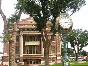
 Dallam County Courthouse |
|
| Location of Dalhart in Texas | |
| Basic data | |
| Foundation : | 1901 |
| State : | United States |
| State : | Texas |
| Counties : |
Dallam County Hartley County |
| Coordinates : | 36 ° 4 ′ N , 102 ° 31 ′ W |
| Time zone : | Central ( UTC − 6 / −5 ) |
| Residents : | 7,930 (as of 2010) |
| Population density : | 714.4 inhabitants per km 2 |
| Area : | 11.1 km 2 (about 4 mi 2 ) of which 11.1 km 2 (about 4 mi 2 ) is land |
| Height : | 1214 m |
| Postal code : | 79022 |
| Area code : | +1 806 |
| FIPS : | 48-18524 |
| GNIS ID : | 1355552 |
| Website : | www.dalhart.org |
| Mayor : | Gene Rahll |
Dalhart is the district capital and seat of the county seat of Dallam County in the US state of Texas in the United States .
geography
The city is located in Dallam and Hartley Counties in the northwest of the Texas Panhandle . It is in the north about 30 km from Oklahoma , in the west about 25 km from New Mexico and has a total area of 11.1 km² without any significant water surface.
Dalhart crossing US Highway 87 and US Highway 385 to US Highway 54 .
history
The place was founded in 1901 at the junction of the Chicago, Rock Island and Pacific Railroad and the Denver to Dallas railway line with the name Twist Junction . It was later renamed Denrock , a combination of the names of the two railway lines. When the first post office opened, the post office gave the name Dalhart as a combination of words for the two counties in which it was located.
In 1912 the city already had 3,500 inhabitants and became the freight center for the surrounding areas. After the first oil discoveries in the Panhandle, Dalhart was one of the first cities to not sell the land to the companies, but to issue drilling licenses.
Demographics
| growth of population | |||
|---|---|---|---|
| Census | Residents | ± in% | |
| 1910 | 2580 | - | |
| 1920 | 2676 | 3.7% | |
| 1930 | 4691 | 75.3% | |
| 1940 | 4682 | -0.2% | |
| 1950 | 5918 | 26.4% | |
| 1960 | 5160 | -12.8% | |
| 1970 | 5705 | 10.6% | |
| 1980 | 6854 | 20.1% | |
| 1990 | 6246 | -8.9% | |
| 2000 | 7237 | 15.9% | |
| 2010 | 7930 | 9.6% | |
| 1930-2000, 2010 | |||
According to the 2000 census, 7,237 people lived here in 2,779 households and 1,939 families. The population density was 651.3 inhabitants per km ². The racial the population was composed of 85.44% White, 1.46% African American, 0.79% Native American, 0.32% Asian, 0.01% Pacific Islander, and 9.96% other ethnic groups. About 2.02% were mixed race and 22.80% of the population were Hispanic or Latino of any race.
Of the 2,779 households, 36.2% had children under the age of 18 living with them. 55.7% of these were married couples living together. 9.6% were single mothers and 30.2% were non-families. 26.8% of all households were single households and there were people living in 12.3% who were 65 years of age or older. The average household size was 2.57 and the average family size was 3.12.
29.7% of the population were under 18 years old, 7.7% 18 to 24, 27.7% 25 to 44, 21.7% 45 to 64, and 13.2% who were 65 years of age or older . The median age was 34 years. For every 100 females of all age groups, there were 95.0 males. For every 100 women aged 18 and over there were 92.8 men.
The median income for a household in the 30,897 USD , and the median income for a family 39,193 USD. Males had a median income of $ 29,521 versus $ 19,899 for females. The per capita income was $ 16,530. 11.8% of the population and 8.5% of families are below the poverty line. Of these, 13.0% were children and adolescents under 18 years of age and 19.5% were 65 or older.
See also
Individual evidence
- ↑ Texas Almanac (PDF; 1.2 MB). Retrieved October 4, 2012
- ↑ US Census ( Memento of the original from July 8, 2013 in the Internet Archive ) Info: The archive link was inserted automatically and has not yet been checked. Please check the original and archive link according to the instructions and then remove this notice. . Retrieved October 16, 2012
