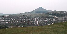
Dedopliszqaro
|
Dedopliszqaro დედოფლისწყარო |
||
| State : |
|
|
| Region : | Kakheti | |
| Municipality : | Dedopliszqaro | |
| Coordinates : | 41 ° 28 ′ N , 46 ° 7 ′ E | |
| Height : | 800 m. ü. M. | |
| Residents : | 5,940 (2014) | |
| Time zone : | Georgian Time (UTC + 4) | |
| Community type: | city | |
|
|
||
Dedopliszqaro ( Georgian დედოფლისწყარო ; also in the form Dedoplis Zqaro ) is a city in eastern Georgia , in the Kakheti region .
It is the administrative seat of the municipality of the same name Dedopliszqaro and has about 5940 inhabitants (2014).
location
Dedopliszqaro is located almost 120 kilometers as the crow flies east-southeast of the state capital Tbilisi and 75 kilometers southeast of the regional capital Telavi at the southeast end of the Gombori mountain range (Georgian გომბორის ქედი Gomboris Kedi ), which runs across Kakheti and it between the wide valley of the Alazani in the northeast and the sich south-west extending, low mountainous Iori highlands , traversed by the Iori . Immediately south of Dedopliszqaro, the Gombori mountain range with the Nikoraszikhe again reaches a height of 1001 m before it gradually merges in a south-easterly direction into the flat Shirak steppe , which extends to the Alasani, which there in its lower reaches the border with Azerbaijan marked.
To the northeast, Alazani and the state border are just under 20 kilometers away.
history
The place was first mentioned in medieval annals from the reign of King Dawit IV the builder around 1100 as a military post. According to tradition, the place name, which means "Queen's Spring", refers to Queen Tamar , who reigned around 1200.
After Kakheti was annexed to the Russian Empire in 1801, the Imperial Russian Army built a base near the village in 1803, which was to serve to defend against Dagestani rebels, and, based on the old name, gave it the Russian name Zarskije Kolodzy ( Russian рарские Колодцы , “Tsar's well "). In 1869, the German entrepreneurs Carl and Werner von Siemens had a refinery built near the village to process the crude oil that had been discovered not far, although it was only in operation for a few years.
The place remained an important military base and housed an important garrison even during the short period of independence of the Democratic Republic of Georgia from 1918 to 1921 . So there was heavy fighting during the invasion of the Soviet Red Army on February 18, 1921.
The Soviet authorities renamed the place Zitelzqaro (Georgian წითელწყარო , " Red Spring "). The Russian form was initially translated as Krasnyje Kolodzy (Russian Красные Колодцы ); In the 1930s, the variant Ziteli-Zkaro (Russian Цители-Цкаро ), adapted to the Georgian name, came into use. The place became the administrative center of a Rajons and received first the status of an urban-type settlement , then in 1963 city rights.
In 1991 the name was changed to Dedopliszqaro .
- Population development
| year | Residents |
|---|---|
| 1959 | 8,492 |
| 1970 | 9,026 |
| 1979 | 9,460 |
| 1989 | 10,249 |
| 2002 | 7,628 |
| 2014 | 5,940 |
Note: census data
Culture and sights
Not far from Dedopliszqaro are the ruins of the medieval fortress Khornabudschi (Georgian ხორნაბუჯი ). The city has a local museum. The Vashlovani National Park extends on the territory of the municipality, about 40 kilometers southeast of the city .
Economy and Infrastructure
Limestone is mined and processed not far from Dedopliszqaro . There are food and light industries in the city.
The city is the end point (kilometer 127 from Tbilisi / Nawtlughi) a opened in 1951 and from 1965 to 1966 with 3000 volts DC electrified railway line , the east of Katschreti of the route Tbilisi - Telavi branches. The line has been out of service since 1992, but has not been dismantled. The regional road to Dedopliszqaro branches off in Chalaubani not far from Sighnaghi from the S5 highway , which connects Tbilisi with the Azerbaijani border at Lagodechi , and runs along the southwest flank of the Gombori mountain range. It continues to the sparsely populated far east of the country.
Individual evidence
- ↑ Population Census 2014 ( Memento of the original from September 20, 2016 in the Internet Archive ) Info: The archive link was inserted automatically and has not yet been checked. Please check the original and archive link according to the instructions and then remove this notice.
- ↑ Alexander Anatolyev: The Power of Productive Cooperation . In: Oil of Russia. No. 4/2003 (English)
- ↑ Article Ziteli-Zkaro in the Great Soviet Encyclopedia (BSE) , 3rd edition 1969–1978 (Russian)
- ↑ Anatolij Archangelʹskij, Vladimir Archangelʹskij: Železnodorožnye stancii SSSR: Spravočnik . tape 2 . Transport, Moscow 1981, p. 207 ( USSR railway stations: manual ; Russian).
- ↑ G. Afonina: Kratkie svedenija o razvitii otečestvennych železnych dorog s 1838 po 1990 g. MPS, Moscow 1995, p. 174 ( Brief information on the development of the national railways from 1838 to 1990 ; Russian).

