
Deidesheim city fortifications
| City fortifications Deidesheim | |
|---|---|
 Remnants of the city wall with the “Rothenturm”, today residential buildings |
|
| Data | |
| place | Deidesheim |
| Construction year | From 1360 at the latest |
| Coordinates | 49 ° 24 ′ 27 " N , 8 ° 11 ′ 11" E |
 In this city plan from 1818 you can see the course of the city wall and the streets that led along it outside and inside. You can also see how the castle was included in the fortification. |
|

The city fortification of Deidesheim ( Rhineland-Palatinate ) was a diamond-shaped ring that was supposed to protect the place from attacks. In addition to the city wall , fortified towers , the city moat and a wall surrounding it belonged to it. The defense system was built from 1360 at the latest and included the castle . In wartime, Deidesheim was largely insignificant as a fortress. Today there are only a few remains of the complex; According to the State of Rhineland-Palatinate's Monument Protection Act, they are considered to be cultural monuments worthy of protection .
history

The city fortifications are closely linked to the history of the origins and development of Deidesheim. The places Niederkirchen and Deidesheim originally formed a large demarcation, which also included Forst and Ruppertsberg , and their final division did not take place until the 19th century. Niederkirchen is regarded as the "mother community" of Deidesheim and Forst and probably also of Ruppertsberg. The Deidesheimer Großgemarkung was in the northwestern part of the Hochstift Speyer , and the Bishop of Speyer was its sovereign.
The first unequivocal distinction between Niederkirchen and Deidesheim was made through written mentions as "in inferiori Dithensheim" (1281) for Niederkirchen and "Oberndydenßheim" for Deidesheim (1360). A moated castle was mentioned indirectly as early as 1292 ; the adjacent settlement is Deidesheim. The details of the origins of the castle are unknown, as is the fact whether, when the castle was built some distance from the old village of Niederkirchen, consideration was given to elevating the new settlement to a town.
It is known, however, that Deidesheim achieved rapid economic growth after its creation, as shown by tax statistics from 1341 by the Hochstift Speyer: Deidesheim, which was probably assessed jointly with Niederkirchen, had to raise a tax of 80 pounds pfennigs every year, more than other places in the Hochstift such as Hambach (70), Maikammer (70), Schifferstadt (40), Kirrweiler (28), Ruppertsberg (22) and Venningen (7).
The castle alone was no longer sufficient to protect the flourishing town, which is why the construction of a fortification around Deidesheim began as early as 1360. The Speyer bishop Gerhard von Ehrenberg allowed the citizens of Deidesheim to raise an indirect tax on wine to finance them; his aim was also to make Deidesheim a city. One of his successors, Nikolaus von Wiesbaden , succeeded in doing this in 1395. The completion of the city fortifications, however, dragged on until the middle of the 15th century because the neighboring Palatinate tried to prevent this.
After its completion, the city fortifications could offer protection from marauding gangs in peacetime; Deidesheim's economy and trade benefited greatly from this. In times of war, however, the fortifications could only partially fulfill their protective function: Deidesheim was conquered and burned down several times in the Middle Ages and the early modern period. Apart from a siege of Deidesheim in late 1621 by Spanish- League troops in the Thirty Years War , Deidesheim was insignificant as a fortified city.
In 1731 the gates of the city were rebuilt again in baroque forms, but the city fortifications had largely lost their protective function at that time, as the development of new attack weapons significantly reduced the military use of the medieval fortress. Due to the population growth in Deidesheim, the city wall had now been built over in many places and the castle moat was “a collecting point for all the outflows from the cattle sheds and the rubble of stones and ruined wall materials”.

After 1818 most parts of the city wall were dismantled and the rampart surrounding the moat was leveled. In 1820 the city gates with the associated kennels were demolished. Where the main south gate used to be, the "King's Garden" was later built in honor of the Bavarian King Maximilian Joseph . The area along the city wall was sold as building land and some towers were rented for residential purposes. In some places houses were built directly on the city wall, so that these parts built with houses can still be seen today.
Fortification
The city wall used to run along Spitalgasse, Grottenmauergasse, Stadtmauergasse and Burggasse; it included the castle with its walls in the fortification - this is the section between Burggasse and Spitalgasse. In this area, the city wall was based on the specifications of the castle guard and extended it to the northwest and southeast. There were also streets outside the city wall: Kirschgartenstrasse, Bleichstrasse, Bennstrasse, Prinz-Rupprecht-Strasse and Johannes-Mungenastweg. Although there is little left of the original structure of the fortification, Deidesheim can be clearly recognized as a fortified town in the Middle Ages thanks to this double ring road network.
The city wall was reinforced with 14 towers and had two city gates - the "Wormser Tor" leading to the north and the "Landauer Tor" leading to the south, also known as the "Dietelpforte". Of the original 14 defense towers, five are still preserved today, but their roofs no longer have their original appearance. The gate tower of the South Gate was one goal zwinger strengthened. The only continuous, free-standing piece of the city wall can still be found in Spitalgasse today. It consists of quarry stone masonry , the battlements used to rest on its corbels .
The city wall was surrounded by the moat, which in turn was preceded by a wall. The moat can still be walked almost everywhere, although it was built over in many places. The city moat was traversed by a watercourse which - compared to the dammed moat of the castle - was very narrow. The moat was only dammed at one point in the west of the city, where the barons von Sturmfeder had a fish pond. The water that flowed through the city moat was diverted from the Weinbach .
Building stock
Remnants of the city fortifications can still be found today, built with house walls or in the foundations of the houses on the west side of Stadtmauergasse, the buildings with even numbers from number 8 to 56. The most striking remains of the Bering , wall remains (Heumarktstrasse 20, Spitalgasse 21/23 and Stadtmauergasse 46), six more or less well-preserved defense towers (Burggasse 7/9, Spitalgasse 9, Spitalgasse 37, Stadtmauergasse 34, Stadtmauergasse 46 and Weinstraße 63), and the remains of a guard house (Weinstraße 66) are described in more detail below:
- Burggasse 7/9
The so-called “Powder Tower” is a round, two-story tower made of rubble stones. At the beginning of the 20th century, only one stump was left, the rest was restored.

Tower around 1910
View from the west

View from the south


- Heumarktstrasse 20
Remnants of the city wall with corbels , today built with the outbuilding.

View from the northeast

View from the northeast


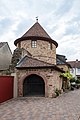
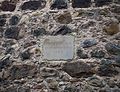
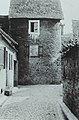
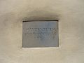
- Spitalgasse 9
House built with the remains of the city wall, the door with rectangular walls probably dates from the 18th century. At the southern end of the "Rothenturm", a two-story, three-quarter-round tower of the city fortifications made of quarry stone masonry . The small gate to Spitalgasse is probably from around 1600.
Residential house with gate
"Rothenturm"
inscription


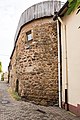
- Spitalgasse 21/23
Remnants of the city wall made of rubble stones, about ten meters long and four and a half meters high. The corbels pointing towards the city, about three meters high, used to carry the battlement .

View from the north

View from the south


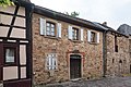
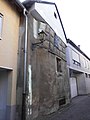
- Spitalgasse 37
"Multenturm": Almost free-standing, almost round tower made of quarry stones, today plastered. It was rededicated into a residential building around 1720 - then three-story. The gable roof protruding over the masonry at the corners dates from the late 19th century.
View from the north, around 1910

View from the west
inscription


- Stadtmauergasse 34
Remains of a round tower of the city fortifications in the rear part of the building; Hard to see from Stadtmauergasse.
- Stadtmauergasse 46
Remnants of the city wall and the remains of a tower in the rear part of the building. Two loopholes from the 14th century are still preserved; Hard to see from Stadtmauergasse.
- Weinstrasse 63
Round, two-story tower of the city fortifications. In the 18th century it was converted for residential purposes and built with adjacent buildings, so that its original shape can only be guessed at.

View from the northwest from Spitalgasse
View from the northeast from Spitalgasse


- Weinstrasse 66
The core of the house contains the remains of the former guard house at the southern gate of the city wall.

View from the east
.jpg)
literature
- Kurt Andermann : Outlines of a history of Deidesheim during the late Middle Ages and the early modern period . In: Kurt Andermann, Berthold Schnabel (Ed.): Deidesheim - Contributions to the history and culture of a city in the wine country . Jan Thorbecke Verlag, Sigmaringen 1995, ISBN 3-7995-0418-4 , p. 81-110 .
- Rolf Mertzenich: A town plan from 1818 - The medieval town development of Deidesheim . In: Bad Dürkheim district (Hrsg.): Heimat-Jahrbuch 1992 . Print shop u. Verlag Englram, Haßloch / Pfalz 1991, ISBN 3-926775-08-4 .
- Berthold Schnabel : Art historical guide through the Deidesheim association . Deidesheim 1976.
- Georg Peter Karn, Rolf Mertzenich: Bad Dürkheim district. City of Bad Dürkheim, municipality of Haßloch, municipalities of Deidesheim, Lambrecht, Wachenheim (= cultural monuments in Rhineland-Palatinate. Monument topography of the Federal Republic of Germany . Volume 13.1 ). Wernersche Verlagsgesellschaft, Worms 1995, ISBN 3-88462-119-X , p. 142-144 .
Web links
Individual evidence
- ^ General Directorate for Cultural Heritage Rhineland-Palatinate (ed.): Informational directory of cultural monuments - Bad Dürkheim district. Mainz 2020, p. 20 (PDF; 5.1 MB).
- ^ Andermann (1995). Pp. 82-83
- ^ Andermann (1995). Pp. 83-84
- ^ Andermann (1995). Pp. 86-87
- ^ Andermann (1995). Pp. 87-89
- ↑ Berthold Schnabel: Deidesheim - pictures from 1870 to 1970 from the city, the district and the forest . Geiger-Verlag, Horb 2015, ISBN 978-3-86595-588-3 , pp. 6 .
- ^ A b c Berthold Schnabel: Art historical guide through the Deidesheim association . Deidesheim 1976, p. 30 .
- ↑ Michael Martin: French Revolution . In: Kurt Andermann, Berthold Schnabel (Ed.): Deidesheim - Contributions to the history and culture of a city in the wine country . Jan Thorbecke Verlag, Sigmaringen 1995, ISBN 3-7995-0418-4 , p. 183 .
- ↑ Heinz Schmitt : billy goat, wine and state visits - Deidesheim in the last 150 years . Ed .: City of Deidesheim. Verlag Pfälzer Kunst, Landau in der Pfalz 2000, ISBN 3-922580-82-3 , p. 57 .