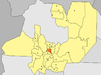
Department of Cerrillos
| Cerrillos | |
|---|---|
| Location of Cerrillos in Salta (Argentina) | |
| Data | |
| Capital | Cerrillos |
| population | 26,320 (2001, INDEC) |
| surface | 640 km² |
| Population density | 41.1 inhabitants / km² |
The department of Cerrillos is located in the center of the province of Salta in northwestern Argentina . It is one of 23 administrative units in the province.
In the north and east it borders on the Departamento Capital , in the south on the Departamento Chicoana and in the west on the Departamento Rosario de Lerma .
The capital of the department is the eponymous Cerrillos .
geography
The largest river is the Río Arias , which flows through the department from north to south. Its tributaries are on the northern border of the Río Ancho and the Río Rosario or Río Toro on the southern border of the department.
climate
The mean temperature is 17 ° C (maximum 36 °; minimum −6 °). The relative humidity fluctuates between 20 and 80 percent. The annual rainfall exceeds 800 mm.
cities and communes
The department of Cerrillos is divided into the following municipalities:
Other places in the department are Sumalao and Villa Los Álamos .
economy
Agriculture mainly produces beans, Virginia, Burley and Criollo tobacco. In addition, the cultivation of peaches, plums, apples, as well as carrots, corn, peppers, pumpkin, sorghum, feed barley, artichokes, wheat, tomatoes, sweet potatoes and other vegetables.
The livestock industry includes cattle, goats and mules.
Web links
- Department of Cerrillos (Spanish)
Coordinates: 24 ° 57 ′ S , 65 ° 27 ′ W

