Aucallama district
| Aucallama district | |||
|---|---|---|---|
 The Aucallama District is located in the southwest of the Huaral Province (marked in red) |
|||
| Symbols | |||
|
|||
| Basic data | |||
| Country | Peru | ||
| region | Lima | ||
| province | Huaral | ||
| Seat | Aucallama | ||
| surface | 706 km² | ||
| Residents | 21,044 (2017) | ||
| density | 30 inhabitants per km² | ||
| founding | February 12, 1821 | ||
| ISO 3166-2 | PE-LIM | ||
| Website | muniaucallama.gob.pe (Spanish) | ||
| politics | |||
| Alcalde District | Hugo Aniano Alvarez Carballido (2019-2022) |
||
| Political party | Movimiento Fuerza Regional (MFR) | ||
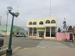
| Aucallama District Administration Building | |||
Coordinates: 11 ° 34 ′ S , 77 ° 11 ′ W
The Aucallama district is located in the province of Huaral in Region Lima in Peru . The district was founded on February 12, 1821. It has an area of 706 km². The 2017 census counted 21,044 residents. In 1993 the population was 11,269, in 2007 it was 16,195. The administrative center is the small town of Aucallama, 9 km from the sea at an altitude of 145 m , with 65,04 inhabitants (as of 2017).
Geographical location
The Aucallama District is located in the southwest of the Huaral Province. It has an approximately 9 km long coastline on the Pacific Ocean . The Río Chancay flows to the sea along the northwestern district boundary. The district extends up to 40 km inland. The foothills of the Peruvian Western Cordillera rise in the southeast of the district .
In the northwest, the Aucallama district borders on the Chancay and Huaral districts , in the northeast on the Sumbilca district , in the southeast on the Huamantanga district ( Canta province ) and in the south on the Ancón district ( Lima province ).
Web links
- Municipalidad Distrital de Aucallama
- Peru: Region Lima (provinces and districts) at www.citypopulation.de
- INEI Perú


