Coishco District
| Coishco District | |||
|---|---|---|---|
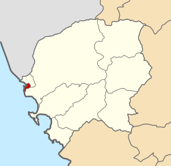
 Location of the district in the province of Santa |
|||
| Symbols | |||
|
|||
| Basic data | |||
| Country | Peru | ||
| region | Ancash | ||
| province | Santa | ||
| Seat | Coishco | ||
| surface | 9.2 km² | ||
| Residents | 15,979 (2017) | ||
| density | 1735 inhabitants per km² | ||
| founding | December 13, 1988 | ||
| ISO 3166-2 | PE-ANC | ||
| Website | www.municoishco.gob.pe (Spanish) | ||
| politics | |||
| Alcalde District | Abel Isaí Sánchez Cruz (2019-2022) |
||
| Political party | Partido Democracia Directa | ||
Coordinates: 9 ° 1 ′ 22 ″ S , 78 ° 36 ′ 55 ″ W.
The Coishco District is one of nine districts of the province of Santa and in the region of Ancash in Peru . Coishco District was established on December 13, 1988. The 9.21 km² district is practically congruent with the city of Coishco . The district had 15,979 inhabitants at the 2017 census. In 1993 the population was 13,300, in 2007 14,832.
The Coishco District is located in the northwest of the Santa Province. It includes the coastal town of Coishco on the Pacific Ocean . The district is about 6 km south of the mouth of the Río Santa and 6 km north of the city of Chimbote . In the north and east, the Coishco district borders on the Santa district , and in the south on the Chimbote district . The national road 1N ( Panamericana ) crosses the district.
Web links
- Municipalidad Distrital de Coishco
- Peru: Region Ancash (provinces and districts) at www.citypopulation.de

