Nepeña district
| Nepeña district | |||
|---|---|---|---|
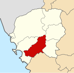
 Location of the district in the province of Santa |
|||
| Symbols | |||
|
|||
| Basic data | |||
| Country | Peru | ||
| region | Ancash | ||
| province | Santa | ||
| Seat | Nepeña | ||
| surface | 458.2 km² | ||
| Residents | 14,324 (2017) | ||
| density | 31 inhabitants per km² | ||
| founding | April 12, 1873 | ||
| ISO 3166-2 | PE-ANC | ||
| politics | |||
| Alcalde District | Pedro Nicolás Carranza López (2019-2022) |
||
| Political party | Movimiento Independiente Regional Río Santa Caudaloso | ||
| Plaza Mayor in San Jacinto | |||
Coordinates: 9 ° 10 ′ S , 78 ° 22 ′ W
The Nepeña District is one of 9 districts in the Santa Province and is located in the Ancash region in western Peru . The 458.24 km² large district was founded on April 12, 1873. At the 2017 census, 14,324 people lived in the Nepeña district. In 1993 the population was 11,260, in 2007 13,860. The administrative center is the small town of Nepeña . There is also the much larger city of San Jacinto in the district .
The Nepeña district is located about 30 km southeast of the city of Chimbote in the hinterland of the Pacific coast in the south of the Santa province. It extends over the arid coastal plain and in the east reaches as far as the Cordillera Negra . The middle reaches of the Río Nepeña flows through the district in a west-southwest direction. Most of the river water is diverted to irrigate the agricultural areas along the river. The landscape is otherwise desert. The Nepeña district borders in the southwest on the Samanco district , in the northwest on the Nuevo Chimbote district , in the north on the Chimbote district , in the northeast on the Caceres del Perú district , in the east on the Moro district and in the south on the Casma district (in the province Casma ). The national road 1N ( Panamericana ) runs along the western district border.
Web links
- Peru: Region Ancash (provinces and districts) at www.citypopulation.de


