Huamachuco District
| Huamachuco District | ||
|---|---|---|
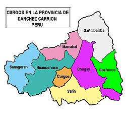
 The Huamachuco district (marked in cobalt blue) is located in the central west of the Sánchez Carrión province |
||
| Symbols | ||
|
||
| Basic data | ||
| Country | Peru | |
| region | La Libertad | |
| province | Sánchez Carrión | |
| Seat | Huamachuco | |
| surface | 415 km² | |
| Residents | 66,902 (2017) | |
| density | 161 inhabitants per km² | |
| ISO 3166-2 | PE-LAL | |
| Website | munihuamachuco.gob.pe (Spanish) | |
| politics | ||
| Alcalde Provincial | Benito Robert Contreras Morales (2019-2022) |
|
| Political party | Fuerza Popular | |
| Huamachuco (2009) | ||
Coordinates: 7 ° 49 ′ S , 78 ° 3 ′ W
The Huamachuco district is located in the Sánchez Carrión province in the La Libertad region in western Peru . The district has an area of 415 km². The 2017 census counted 66,902 residents. In 1993 the population was 37,708, in 2007 it was 52,459. The administrative seat of the district is the provincial capital Huamachuco at an altitude of 3110 m with 41,613 inhabitants (as of 2017).
About 6 km northwest of the city of Huamachuco is the Marcahuamachuco archaeological complex.
Geographical location
The Huamachuco district is located on the eastern flank of the Western Peruvian Cordillera in the central west of the Sánchez Carrión province. In the east, the district extends to the west bank of the Río Chusgón . The western and central part of the district is drained to the north via the Río Condebamba .
The Huamachuco district on the south by the districts Sarin , Cachicadan and Quiruvilca ( province of Santiago de Chuco ), on the west by the district Sanagorán , on the north by the district Marcabal and on the east by the districts Chugay and Curgo .
Localities
In addition to the capital Huamachuco, there are the following larger places in the district:
- Capuli (804 inhabitants)
- Carabamba (505 inhabitants)
- Chochoconda (658 inhabitants)
- Choquizonguillo (677 inhabitants)
- Coigobamba Bajo (608 inhabitants)
- Colpa Yanasanira (595 inhabitants)
- El Toro (580 inhabitants)
- La Arena (785 inhabitants)
- La Colpa (506 inhabitants)
- La Cuchilla (555 inhabitants)
- Pallar Alto (698 inhabitants)
- Pallar Bajo (575 inhabitants)
- Paranchique (852 inhabitants)
- Shiracmaca (2051 inhabitants)
- Urpay (593 inhabitants)
- Vaqueria (549 inhabitants)
- Yanac (510 inhabitants)
Web links
- Municipalidad Provincial de Sánchez Carrión
- Peru: Region La Libertad (provinces and districts) at www.citypopulation.de
- INEI Perú


