Marcabal District
| Marcabal District | |
|---|---|
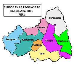
 The Marcabal district (marked pink) is located in the north of the Sánchez Carrión province |
|
| Basic data | |
| Country | Peru |
| region | La Libertad |
| province | Sánchez Carrión |
| Seat | Marcabal |
| surface | 235 km² |
| Residents | 10,431 (2017) |
| density | 44 inhabitants per km² |
| ISO 3166-2 | PE-LAL |
| politics | |
| Alcalde District | Sergio Sandoval Gaitan (2019-2022) |
Coordinates: 7 ° 42 ′ S , 78 ° 2 ′ W
The Marcabal district is located in the Sánchez Carrión province in the La Libertad region in western Peru . The district has an area of 235 km². The 2017 census counted 10,431 residents. In 1993 the population was 11,820, in 2007 14,807. The administrative seat of the district is the 2930 m high village of Marcabal with 343 inhabitants (as of 2017). Marcabal is located 12 km north of the provincial capital Huamachuco .
Geographical location
The Marcabal district is located on the eastern flank of the Peruvian Western Cordillera in the north of the Sánchez Carrión province. It stretches between the two rivers Río Condebamba (in the west) and Río Chusgón in the east, both tributaries of the Río Marañón .
The Marcabal district is bordered to the south by the District Huamachuco , on the west by the district Sanagorán , on the north by the districts Cajabamba and Sitacocha (both in the province Cajabamba ), in the northeast on the district Sartimbamba and the east by the district Chugay .
Web links
- Peru: Region La Libertad (provinces and districts) at www.citypopulation.de
- INEI Perú