Iñapari district
| Iñapari district | |
|---|---|
 Location of the Iñapari district (marked in red) in the Tahuamanu province and in the Madre de Dios region |
|
| Basic data | |
| Country | Peru |
| region | Madre de Dios |
| province | Tahuamanu |
| Seat | Iñapari |
| surface | 13,701 km² |
| Residents | 2756 (2017) |
| density | 0.2 inhabitants per km² |
| founding | December 26, 1912 |
| ISO 3166-2 | PE-MDD |
| Website | www.munitahuamanu.gob.pe (Spanish) |
| politics | |
| Alcalde Provincial | José Abraham Cardozo Mouzully (2019-2022) |
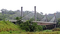
| Puente de la Integración de Acre | |
Coordinates: 10 ° 57 ′ S , 69 ° 35 ′ W
The Iñapari district is located in the Tahuamanu Province in the Madre de Dios region in southeastern Peru . The district was established on December 26, 1912. It extends over an area of 13,701 km². The 2017 census counted 2,756 inhabitants. In 1993 the population was 841, in 2007 it was 1299. The district administration is located in the 220 m high provincial capital Iñapari with 2140 inhabitants (as of 2017). Iñapari is located on the Río Acre River at the border triangle Peru-Brazil-Bolivia.
Geographical location
The Iñapari district is located in the Amazon lowlands . It extends over the west and north of the Tahuamanu Province. The Río Las Piedras delimits the district in the southwest, the Río Acre in the northeast.
The district Iñapari borders in the northwest with the district Purús ( province Purús ), in the north with Brazil, in the east with Bolivia, in the southeast with the districts Iberia and Tahuamanu , in the southwest with the districts Las Piedras and Tambopata ( province Tambopata ) as well as in the extreme West to Sepahua District ( Atalaya Province ).
Web links
- Municipalidad Provincial de Tahuamanu
- Peru: Region Madre de Dios (provinces and districts) at www.citypopulation.de
- INEI Perú
