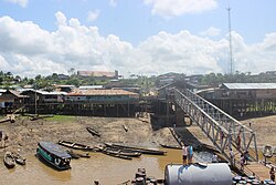
Pebas District
| Pebas District | |
|---|---|
 The district of Pebas is located in the northwest of the province of Mariscal Ramón Castilla |
|
| Basic data | |
| Country | Peru |
| region | Loreto |
| province | Mariscal Ramón Castilla |
| Seat | Pebas |
| surface | 11,232 km² |
| Residents | 12,694 (2017) |
| density | 1.1 inhabitants per km² |
| founding | February 7, 1866 |
| ISO 3166-2 | PE-LOR |
| Website | munipebas.gob.pe (Spanish) |
| politics | |
| Alcalde District | Luis Demetrio Vasquez Rubio (2019-2022) |
| Pebas | |
Coordinates: 3 ° 19 ′ S , 71 ° 52 ′ W
The district of Pebas is located in the Mariscal Ramón Castilla province of the Loreto region in northeastern Peru . The district founded on February 7, 1866 has an area of 11,232 km². The 2017 census counted 12,694 inhabitants. In 1993 the population was 12,590, in 2007 13,624. The administrative center is the small town of Pebas, 101 m high on the north bank of the Amazon , with 4039 inhabitants (as of 2017). Pebas is located 160 km west-northwest of the provincial capital Caballococha and 160 km east-northeast of the regional capital Iquitos .
The indigenous peoples Peba-Yagua , Huitoto and Tucano live in the district area .
Geographical location
The Pebas district is located in the Peruvian Amazon in the northwest of the Mariscal Ramón Castilla province. The Amazon traverses the district in an easterly direction. The area consists mainly of rainforest.
The Pebas district borders on the Las Amazonas district ( Maynas province ) in the west, the Putumayo and Yaguas districts ( Putumayo province ) in the north, the San Pablo district in the east and the Yavarí district in the south .
Individual evidence
- ^ Peru: Loreto Region, Provinces and Districts . www.citypopulation.de. Retrieved February 22, 2020.
