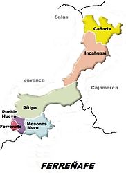
Pueblo Nuevo District (Ferreñafe)
| Pueblo Nuevo District | |
|---|---|
 Location of the district of Pueblo Nuevo (colored dark red) in the province of Ferreñafe |
|
| Basic data | |
| Country | Peru |
| region | Lambayeque |
| province | Ferreñafe |
| Seat | Pueblo Nuevo |
| surface | 28.9 km² |
| Residents | 14,503 (2017) |
| density | 502 inhabitants per km² |
| founding | 17th February 1951 |
| ISO 3166-2 | PE-LAM |
| Website | munipueblonuevo.gob.pe (Spanish) |
| politics | |
| Alcalde District | Jaime Antonio Chicoma Perleche (2019-2022) |
Coordinates: 6 ° 38 ′ 25 ″ S , 79 ° 47 ′ 46 ″ W.
The Pueblo Nuevo district is located in the Ferreñafe Province in the Lambayeque region in northwestern Peru . The district was established on February 17, 1951. It has an area of 28.88 km². The 2017 census counted 14,503 residents. In 1993 the population was 10,995, in 2007 it was 12,046. The seat of the district administration is the 57 m high city Pueblo Nuevo with 13,733 inhabitants (as of 2017). Pueblo Nuevo forms the western part of the metropolitan area of the provincial capital Ferreñafe .
The Pueblo Nuevo district is located in the extreme southwest of the Ferreñafe province. It is located in the coastal plain of northwestern Peru just under 15 km north of the city of Chiclayo and just under 20 km from the Pacific coast. Irrigated agriculture is practiced in the district area.
The Pueblo Nuevo district borders the Ferreñafe district to the north, east and south-east . To the south and west is the Lambayeque district . In the extreme northwest, the Pueblo Nuevo district borders the Mochumí district .
Individual evidence
- ↑ a b PERU: Lambayeque region - provinces and districts . www.citypopulation.de. Retrieved March 26, 2020.