Raimondi district
| Raimondi district | |
|---|---|
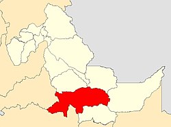
 Location of the district (marked in red) in the Ucayali region |
|
| Basic data | |
| Country | Peru |
| region | Ucayali |
| province | Atalaya |
| Seat | Atalaya |
| surface | 14,582 km² |
| Residents | 39,732 (2017) |
| density | 2.7 inhabitants per km² |
| founding | July 2, 1943 |
| ISO 3166-2 | PE-UCA |
| Website | muniatalaya.gob.pe/web/index.php (Spanish) |
| politics | |
| Alcalde Provincial | Adelmo Segundo Guerrero Enciso (2019-2022) |
| The city of Atalaya on the Río Tambo | |
Coordinates: 10 ° 44 ′ S , 73 ° 45 ′ W
The Raimondi district (alternative spelling: Raymondi district ) is located in the Atalaya province in the Ucayali region in eastern Peru . The district was established on July 2, 1943. The district was named after the Italian naturalist Antonio Raimondi (1826–1890).
The district has an area of 14,582 km². At the 2017 census, 39,732 residents lived in the district. In 1993 the population was 18,341, in 2007 37,782. The district administration is located in the provincial capital Atalaya with 12,946 inhabitants (as of 2017) on the west bank of the Río Tambo at an altitude of 228 m . About 2 km north of Atalaya, the Río Tambo joins the Río Urubamba coming from the southeast to form the Río Ucayali .
Geographical location
The Raimondi district lies on the western edge of the Amazon basin . The Río Urubamba and Río Ucayali cross the district in a north-westerly and north-westerly direction. In the northwest rises the mountain range of the Sira Mountains . In the south, the district includes the catchment areas of the left Urubamba tributaries Río Cumarillo and Río Huaro and in the west that of the left Ucayali tributary Río Unine . In the east, the district extends over the catchment areas of Río Mapuillo, Río Inuya and Río Cohengua .
The Raimondi district borders in the west with the district Puerto Bermúdez ( province Oxapampa ), in the north with the district Tahuanía , in the northeast with the district Yurúa , in the east with the district Purús ( province Purús ), in the southeast with the district Sepahua and in the southwest to the districts of Río Tambo ( Satipo Province ) and Pichanaqui ( Chanchamayo Province ).
Individual evidence
- ↑ a b Peru: Ucayali Region - Provinces & Districts . www.citypopulation.de. Retrieved May 12, 2020.
