Oxapampa Province
| Oxapampa Province | |||
|---|---|---|---|
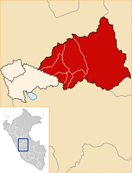
 Location of the province in the Pasco region |
|||
| Symbols | |||
|
|||
| Basic data | |||
| Country | Peru | ||
| region | Pasco | ||
| Seat | Oxapampa | ||
| surface | 18,673.8 km² | ||
| Residents | 87,470 (2017) | ||
| density | 4.7 inhabitants per km² | ||
| founding | November 27, 1944 | ||
| ISO 3166-2 | PE-PAS | ||
| Website | www.munoxapampa.com (Spanish) | ||
| politics | |||
| Alcalde Provincial | Juan Carlos La Torre Moscoso (2019-2022) | ||
| Río Huancabamba | |||
Coordinates: 10 ° 35 ′ S , 75 ° 25 ′ W
The province of Oxapampa is one of the three Peruvian provinces that together make up the Pasco region. The provincial capital is Oxapampa . The province was officially registered on November 27, 1944 and is very well known because it was founded by German and Austrian immigrants. Therefore, one of the official languages of the province in addition to Spanish and several indigenous dialects German . The province of Oxapampa extends over 18,673.79 km². The 2017 census counted 87,470 inhabitants, 10 years earlier it was 81,929.
Geographical location
The province extends over the Vorandine region between the Peruvian Central Cordillera in the west and the Sira Mountains in the east. The area is drained by the River Pachitea to the Río Ucayali .
Administrative division
The province of Oxapampa is divided into the following eight districts. The district of Oxapampa is the seat of the provincial administration.
| District | Administrative headquarters |
|---|---|
| Chontabamba | Chontabamba |
| Constitución | Ciudad Constitución |
| Huancabamba | Huancabamba |
| Oxapampa | Oxapampa |
| Palcazú | Iscozacín |
| Pozuzo | Pozuzo |
| Puerto Bermúdez | Puerto Bermúdez |
| Villa Rica | Villa Rica |
literature
- Dionisio Ortiz OFM: Oxapampa. Estudio de una provincia de la selva del Perú , 2 volumes. Editorial San Antonio, Lima 1967.


