Pozuzo District
| Pozuzo District | |
|---|---|
 Location of the district in the province of Oxapampa |
|
| Basic data | |
| Country | Peru |
| region | Pasco |
| province | Oxapampa |
| Seat | Pozuzo |
| surface | 750.9 km² |
| Residents | 4511 (2017) |
| density | 6 inhabitants per km² |
| founding | November 29, 1918 |
| ISO 3166-2 | PE-PAS |
| Website | munipozuzo.com (Spanish) |
| politics | |
| Alcalde District | Nilton Ballesterso Crisanto (2019-2022) |
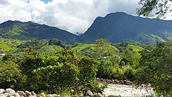
| Landscape in the Pozuzo district | |
Coordinates: 10 ° 4 ′ S , 75 ° 33 ′ W
The Pozuzo district is located in the Oxapampa Province in the Pasco administrative region in Peru . The district was founded on November 29, 1918 during the government of the Peruvian President José Pardo y Barreda . It extends over an area of 750.87 km². At the 2017 census, the population was 4511. In 1993 there were 5053 people in the district and 7760 in 2007. The administrative seat is the small town of Pozuzo .
Geographical location
The Pozuzo district is located on the eastern flank of the Peruvian Central Cordillera . The district borders the Huánuco region to the west and north . The national road 5N crosses the district in a north-south direction.
Web links
Commons : Pozuzo District - Collection of images, videos and audio files
- munipozuzo.com - Municipalidad Distrital de Pozuzo
- Peru: Region Pasco (provinces and districts) at www.citypopulation.de
