Santa Cruz District (Palpa)
| Santa Cruz District | |
|---|---|
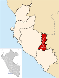
 The district of Santa Cruz is located in the southwest of the province of Palpa (marked in red) |
|
| Basic data | |
| Country | Peru |
| region | Ica |
| province | Palpa |
| Seat | Santa Cruz |
| surface | 254 km² |
| Residents | 927 (2017) |
| density | 3.6 inhabitants per km² |
| founding | January 16, 1953 |
| ISO 3166-2 | PE-ICA |
| Website | munisantacruz-palpa.gob.pe (Spanish) |
| politics | |
| Alcalde District | Robert Teddy Palomino Matta (2019-2022) |
| Political party | Acción Popular |
Coordinates: 14 ° 29 ′ S , 75 ° 15 ′ W
The Santa Cruz district is located in the Palpa Province in the Ica region in southwestern Peru . The district was established on January 16, 1953. The district name Santa Cruz ("Holy Cross") refers to Ramón Casaus y Torres , 1815-1845 Archbishop of Guatemala .
The district has an area of 332.78 km². At the 2017 census, 927 people lived in the Santa Cruz district. In 1993 the population was 1151, in 2007 it was 1060. The administrative center is the town of Santa Cruz , located on the eastern bank of the Río Santa Cruz at an altitude of 526 m . Santa Cruz is located about 9 km northwest of the provincial capital Palpa . The only larger town in the district is San Francisco with 386 inhabitants. The national road 1S ( Panamericana ) from Ica to Palpa crosses the district.
Geographical location
The Santa Cruz district is located at the foot of the Peruvian Western Cordillera in the southwest of the Palpa province. The district extends along the middle reaches of the Río Santa Cruz (also Quebrada Santa Cruz), a right tributary of the Río Grande , which falls dry most of the time. The area is desert-like, especially the southern part of the district, which is in the coastal desert area of southern Peru. The Santa Cruz district has a longitudinal extension in north-south direction of about 32 km and an average width of 5 km.
The district of Santa Cruz borders in the west on the district Santiago ( province Ica ), in the north on the district Tibillo , in the east on the district Río Grande , in the extreme southeast on the district Llipata and in the south on the district Changuillo ( province Nasca ).
Ciudad Perdida de Huayuri Archaeological Complex
The archaeological complex Ciudad Perdida de Huayuri ( ⊙ ) is located in a gorge east of the Río Santa Cruz 4 km south of San Francisco. The settlement complex was probably inhabited between 1100 and 1476 by the Poroma family. It is believed that up to 5000 people lived there at the time.
![]() Map with all coordinates: OSM | WikiMap
Map with all coordinates: OSM | WikiMap
Individual evidence
- ↑ PERU: Region Ica: Provinces & Districts . www.citypopulation.de. Accessed April 30, 2020.