Palpa Province
| Palpa Province | |
|---|---|
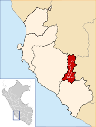
 Location of the province in the Ica region |
|
| Basic data | |
| Country | Peru |
| region | Ica |
| Seat | Palpa |
| surface | 1,232.9 km² |
| Residents | 13,232 (2017) |
| density | 11 inhabitants per km² |
| founding | December 27, 1963 |
| ISO 3166-2 | PE-ICA |
| Website | www.munipalpa.gob.pe (Spanish) |
| politics | |
| Alcalde Provincial | José Luis Montaño Yarasca (2019-2022) |
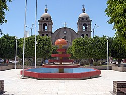
| Plaza de Armas in Palpa | |
Coordinates: 14 ° 32 ′ S , 75 ° 11 ′ W
The Palpa Province is one of five provinces in the Ica region on the Pacific coast of Peru . The province has an area of 1232.9 km². The population was 13,232 in 2017. In 2007 this was 12,875. The administrative seat is the city of Palpa .
Geographical location
The province of Palpa borders in the north on the province Huaytará (Huancavelica), in the east on the province Lucanas (Ayacucho), in the south on the province Nasca and in the west on the province Ica .
Administrative division
The province of Palpa is divided into five districts ( distritos ). The Palpa district is the seat of the provincial administration.
| District | Administrative headquarters |
|---|---|
| Llipata | Llipata |
| Palpa | Palpa |
| Rio Grande | Rio Grande |
| Santa Cruz | Santa Cruz |
| Tibillo | Tibillo |
Individual evidence
- ^ A b Peru: Ica Region - Provinces and Districts . www.citypopulation.de. Retrieved December 6, 2019.
