Llipata district
| Llipata district | |
|---|---|
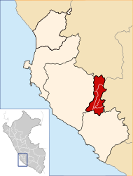
 The Llipata District is located in the southeast of the Palpa Province (marked in red) |
|
| Basic data | |
| Country | Peru |
| region | Ica |
| province | Palpa |
| Seat | Llipata |
| surface | 183 km² |
| Residents | 1555 (2017) |
| density | 8.5 inhabitants per km² |
| founding | January 16, 1953 |
| ISO 3166-2 | PE-ICA |
| politics | |
| Alcalde District | José Luis Hinostroza Berrocal (2019-2022) |
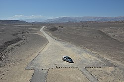
| Desert landscape in the Llipata district | |
Coordinates: 14 ° 34 ′ S , 75 ° 12 ′ W
The district of Llipata is located in the province of Palpa in the region of Ica in southwestern Peru . The district was established on January 16, 1953. It has an area of 183 km². At the 2017 census, there were 1,555 residents in the Llipata district. In 1993 the population was 1372, in 2007 it was 1420. The administrative seat is the town of Llipata , located in the northwest of the district at an altitude of 303 m , with 376 inhabitants (as of 2017). Llipata is located 4 km southwest of the provincial capital Palpa . The only larger town in the district is Carlos Tijero with 771 inhabitants. The national road 1S ( Panamericana ) from Palpa to Nasca crosses the district in a south-southeast direction.
Geographical location
The Llipata district is located at the foot of the Peruvian Western Cordillera in the southeast of the Palpa province. The Río Grande crosses the far west of the district in a southerly direction. In the northwest the district extends to the confluence of the Río Vizcas in the Río Grande, in the central south the district boundary runs along the north bank of the Río Ingenio (also Quebrada Ingenio). Irrigated agriculture is practiced along the rivers. Otherwise the area consists of desert. The western foothills of the Western Cordillera rise in the east of the district.
The Llipata district borders in the northwest on the districts of Santa Cruz and Río Grande , in the north on the district Palpa , in the northeast on the district Ocaña ( province Lucanas , region Ayacucho ), in the southeast on the district El Ingenio and in the southwest on the district Changuillo (the last two in the Nasca province ).
Geoglyph
There are several geoglyphs in the Llipata district that have been listed as historical monuments since 1993 and 2004 respectively. Three larger groups of geoglyphs are called Shamán y sus aliados, Animales del desierto y donde observarlos and La Orca de Piedras Gordas.
Individual evidence
- ↑ PERU: Region Ica: Provinces & Districts . www.citypopulation.de. Retrieved May 1, 2020.
- ↑ a b Ministerio de Cultura presentó tres grupos de geoglifos en Palpa . Ministerio de Cultura. Retrieved February 3, 2020.
