Río Grande District (Palpa)
| Río Grande district | |
|---|---|
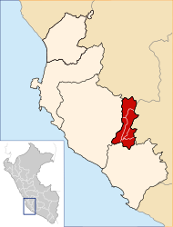
 The district of Río Grande is located in the north-east of the province of Palpa (marked in red) |
|
| Basic data | |
| Country | Peru |
| region | Ica |
| province | Palpa |
| Seat | Rio Grande |
| surface | 314 km² |
| Residents | 2658 (2017) |
| density | 8.5 inhabitants per km² |
| founding | January 16, 1953 |
| ISO 3166-2 | PE-ICA |
| politics | |
| Alcalde District | Moisés Ramírez Aguayo (2019-2022) |
| Political party | Acción Popular |
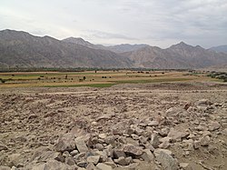
| Landscape north of the main town Río Grande | |
Coordinates: 14 ° 31 ′ S , 75 ° 12 ′ W
The district of Río Grande is located in the province of Palpa in the region of Ica in southwestern Peru . The district was established on January 16, 1953. It has an area of 314 km². At the 2017 census, there were 2,658 residents in the Río Grande district. In 1993, the population was 3,245, in 2007 the 2,731th administrative headquarters is not far from the east bank of the Rio Grande at an altitude of 354 m nearby places Río Grande with 1,394 inhabitants (2017). Río Grande is located 2 km northwest of the provincial capital Palpa . The national road 1S ( Panamericana) from Ica to Palpa crosses the south of the district.
Geographical location
The Río Grande district extends along the central reaches of the Río Grande in the western foothills of the Western Peruvian Cordillera . The district is located in the north-east of Palpa Province. The maximum longitudinal extent in SSW-NNE direction is about 42 km, the maximum width is almost 15 km. In the south, the district extends to the confluence of the Río Vizcas in the Río Grande. In the west, the watershed to the Río Santa Cruz, which runs further to the west, forms the district boundary .
The Río Grande district borders on the Santa Cruz district in the west, the Tibillo district in the northwest , the Huac-Huas district ( Lucanas province , Ayacucho region ) in the northeast, the Llauta district (also in the Lucanas province) in the east , in the southeast to the Palpa district and in the extreme south to the Llipata district .
Geoglyph
The geoglyph Líneas de Palpa ( ⊙ ) are located in the district about one kilometer east of the main town, Río Grande .
![]() Map with all coordinates: OSM | WikiMap
Map with all coordinates: OSM | WikiMap
Individual evidence
- ↑ PERU: Region Ica: Provinces & Districts . www.citypopulation.de. Retrieved May 1, 2020.
