Dordogne limousine
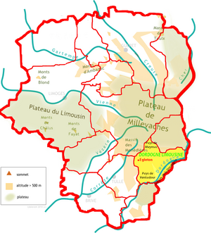
The Dordogne limousine is a traditional French landscape on the south-eastern edge of the Corrèze department . It is located in historic Limousin and is part of the Nouvelle-Aquitaine region .
geography
The Dordogne sedan, German as Dordogne Limousin character translate, lies with its focus in the Pays de Ventadour just east of the city of Égletons .
The landscape is surrounded by the following natural spaces:
- the Massif des Monédières and the Pays d'Ussel in the north
- the Artense and the Mauriacois in the east
- the Xaintrie in the south
- the Pays de Tulle in the west.
In turn, it is further subdivided into the following landscapes:
- the Gorges de la Dordogne
- the Pays de Bort
- the Pays de Meymac
- the Pays de Neuvic
- the Pays de Ventadour
Administratively, the Dordogne limousine extends over the cantons of Argentat , Égletons and Haute Dordogne and forms part of the communal associations Communauté de communes de Ventadour-Égletons-Monédières and Communauté de communes Xaintrie Val'Dordogne .
Geomorphologically, the Dordogne limousine forms a leveled hull surface on the eastern slope of the Plateau de Millevaches with heights between 500 and 700 meters, into which the Dordogne with its right-hand tributaries has cut like a gorge. The difference in altitude is a good 250 meters.
Hydrography
The Dordogne limousine is named after the Dordogne, which generally flows south-west along its southeastern border towards the Aquitaine Basin . Several right-hand tributaries of the Dordogne, draining from north to south , crisscross the old hull area, some like gorges, including Diège , Triouzoune , Vianon , Luzège , Sombre and Doustre (arranged from north-east to south-west) .
geology
Geologically, the Dordogne limousine belongs entirely to the crystalline basement of the western Massif Central . Upcoming are mica schist , paragneiss , leuco granite and other granitoids as well as volcanic rocks and associated sediments.
The terran can be divided into two structurally completely different sections. In the west it forms part of the Massif de Millevaches - a 150 km long, north-south oriented, parautochthonous basement bulge. From its east side, the lower gneiss cover has slipped off due to the Ambrugeat fault and forms the eastern part of the terran. The Massif de Millevaches is called Chaîne corrèzienne in the Dordogne limousine and is built on both edges of mica schists from the parautochthonous mica slate unit , but the central part is formed by 335 to 330 million year old leukogranites of the Viséum . Égletons itself lies on a strongly regulated, porphyry granite - the Égletons granite . The lower gneiss cover consists mainly of amphibolite facies, plagioclash-containing paragneiss and migmatites .
At the extreme northeastern edge of the Dordogne limousine, the Sillon houiller just brushes past in a north-northeast direction - a huge fracture zone that delimits the western section of the Massif Central , which collapsed in the Upper Carboniferous with simultaneous lateral shifts and is partly designed as a small, narrow coal basin , like the 16 kilometer here long and 3 kilometers wide braziers of Champagnac-Ydes . To the east of the narrow coal basin, shortly before Bort-les-Orgues , gneisses of the lower gneiss cover appear again. A special feature is a 2.5 kilometer long phonolite river at the northern end of the coal basin ( Orgues de Bort ), which rests on Oligocene sediments. It belongs to the huge stratovolcano of the Cantal . In addition to the phonolite, small Miocene basalt domes should be mentioned, as in Marèges and Sérandon - remnants of the initial basaltic volcanism on the Cantal.
economy
In economic terms, the three sectors of agriculture (with cattle breeding), forestry and handicrafts are important in the Dordogne limousine .
literature
- Frédéric Zégierman: Le Guide des Pays de France, Sud . Fayard, 1999.
Individual evidence
- ↑ Monier, G .: Pétrologie des granitoïdes du Sud-Millevaches, (Massif Central francais). Minéralogie, géochimie, géochronologie, Thèse 3ème cycle (doctoral thesis) . Univ. Clermont-Ferrand, Clermont-Ferrand, France 1980, pp. 288 .

