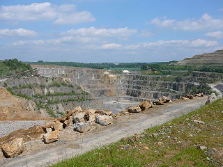
Dornaper limestone area
| Dornaper limestone area | |||
|---|---|---|---|
| The Osterholz mine near Schöller | |||
| Systematics according to | Handbook of the natural spatial structure of Germany | ||
| Greater region 1st order | Low mountain range threshold | ||
| Greater region 2nd order | Rhenish Slate Mountains | ||
| Main unit group | 33 → Süderbergland |
||
| About main unit | 337 → Bergisch-Sauerland lowlands |
||
| 4th order region (main unit) |
337 1 → Niederbergisch-Märkisches hill country |
||
| 5th order region | 337 1 .1 → Bergisch-Märkisches hill country |
||
| Natural space |
337 1 .16 → Dornaper limestone area |
||
| Geographical location | |||
| Coordinates | 51 ° 14 '22.1 " N , 7 ° 2' 21" E | ||
|
|||
| Local area | Wieden , Dornap , Hahnenfurth , Schöller , Gruiten | ||
| local community | Wuppertal , Haan | ||
| state | North Rhine-Westphalia | ||
| Country | Germany | ||
The Dornaper Kalkgebiet is a small-scale natural unit with the order number 337 1 .16 in the area of the Bergisch cities of Wuppertal (districts Wieden , Dornap , Hahnenfurth and Schöller ) and Haan (district Gruiten ).

The narrow depression at 150 to 190 m height consists of heavily folded mass limestone ( Eskesberger Kalk and Schwelmer Kalk ) from the central Devon northwest of Vohwinkel, which has been eroded and karstified by heavy rainfall and is surrounded all around by higher ridges and knolls . To the north, the surface of the depression slopes down towards the Düssel . Numerous dry valleys and sinkholes divide the area there. Isolated deposits of quartz sand , quartz gravel and clays are found in the sinkholes .
The lime in the Dornaper Valley has been mined in quarries and pits since the Middle Ages, and today it is also industrially mined. The opencast mines include the abandoned pit 7 , pit 10 , pit Schickenberg , pit Vossbeck and the pit Dorp . The Hanielsfeld , Hahnenfurth and Osterholz opencast mines are still in operation today.

