
Greetings
|
Greetings
City of Haan
|
||
|---|---|---|
 |
||
| Height : | 120 m | |
| Residents : | 6000 (Jan. 1, 2010) | |
| Incorporation : | 1st January 1975 | |
| Postal code : | 42781 | |
| Area code : | 02104 | |
Location of Gruiten in Haan |
||


Gruiten (spoken: Grüten ; see the information on the sound shift in the pronunciation of Duisburg under Dehnungs-i and Rhenish place names ) is a district of the city of Haan in the Mettmann district in North Rhine-Westphalia , has about 6000 inhabitants and is 159 m above sea level . NN .
Gruiten consists of Gruiten-Dorf and Gruiten, where the new town center, the former town hall and the train station are located. The Düssel flows through Gruiten-Dorf, which is fed here by the Kleine Düssel .
coat of arms
On the coat of arms of the municipality of Gruiten, a natural rock face rising to the left is to be seen as a symbol for the lime mining, next to which a silver, upright pickaxe with a golden handle hovers on the right.
history
The settlement is dated around the year 1000. There are only guesses as to the origin of the name. It should point out the origin and nature of the soil conditions, for example sand, gravel, stone rubble and lime.
In 1806, the honors Haan, Ellscheid , Millrath (now part of Erkrath), Gruiten, Schöller and Sonnborn (both now part of Wuppertal) came under French rule and were united to form " Mairie Haan". In 1815 this administrative unit was placed under Prussian administration and rededicated as the mayor's office in Haan .
In 1894, Haan left the association because the community was striving for city rights, and Millrath, Gruiten and Schöller formed the Gruiten mayor , which was converted into the Gruiten office in 1927 . From 1929 the mayor's office belonged to the Düsseldorf-Mettmann district and existed until 1975.
Since the incorporation of Gruiten into Haan on January 1, 1975, the town hall is no longer needed; today it is used by the Bergisch-Rheinischer Wasserverband .
From 1930 to 1952 the Mettmann – Gruiten catenary bus operated between Mettmann and Gruiten , the first modern trolleybus in Germany.
In 1945, at the end of the Second World War , the destruction of the place was avoided by handing it over to the US troops without a fight. The German battalion leader Johannes Baczewski was responsible for this .
For centuries, the economic focus was on lime mining . Smaller pits and quarries are still clearly visible today in the landscape and in the Düsseldorf valley. You cannot miss pit 7 , which was used until the end of the 1960s. Today the pit 7 is a nature reserve and recreational area. The dolomite stone was transported to the lime works near the train station first on a factory railway, later on a cable car and finally on a specially built factory road. The “Puderberg”, an artificial hill made of dust, earth and stones directly on the rails to Hochdahl- Millrath , is a striking remnant from this time .
The former importance of limestone mining for Gruiten has left many other traces. Many buildings in Gruiten are made entirely or partially of hewn dolomite (calcareous rock).
Incorporations
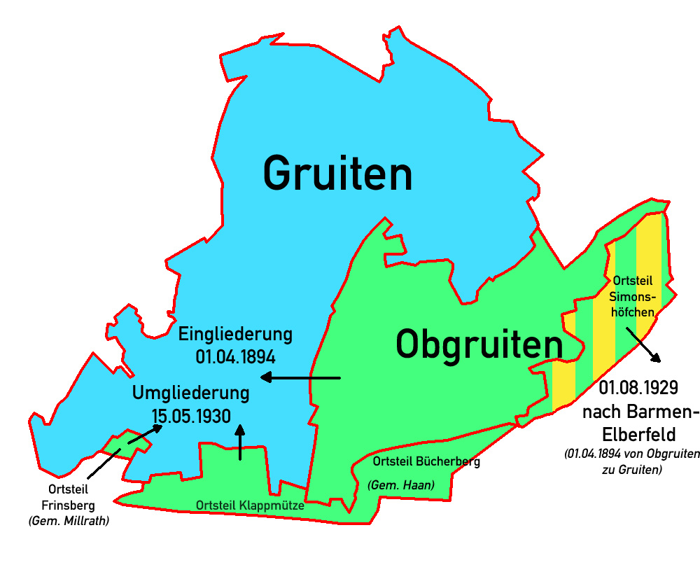
- On April 1, 1894, the municipality of Obgruiten was incorporated into Gruiten. The Haaner residential areas “Simonshöfchen”, “Ölbers”, “Linden” and two smaller areas were re-municipalityed to Gruiten.
- On August 1, 1929, the Gruitener, until 1894 Haaner, residential area "Simonshöfchen" was moved to Barmen-Elberfeld.
- On May 15, 1930, the Haaner residential areas "Klappmütze" (Ellscheid) and "Bücherberg" as well as the Millrath residential area "Frinsberg" were reassigned to Gruiten.
- On January 1, 1975, Gruiten was incorporated into Haan as part of the municipal reorganization in North Rhine-Westphalia.
Culture and sights
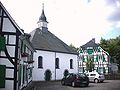
The district of Gruiten-Dorf with its well-preserved half-timbered houses is the largest intact historical settlement in the Haan city area. The old Romanesque church tower has been preserved in the cemetery .
The oldest residential building is the "Haus am Quall", of which at least one wing can be dated back to the 14th century. It was originally part of a farm on the quall. 1978–1980 it was reconstructed and rebuilt and used today for celebrations, teaching and information events.
The evangelical reformed church from 1721 in the ensemble with preaching house (1682) and old parsonage (1764) and the remaining church tower of the old fortified church in the Catholic cemetery (end of the 12th century) let you experience the traditional houses like the Bergische Villages used to look like. The Roman Catholic St. Nicholas Church dates from 1879.
Ev.-ref. Church with preaching house and rectory

Catholic Church of St. Nicholas

Am Doren - revived around 1675

Haus Am Quall - Niederberg farm castle

Offers (under monument protection) - first mentioned in a document in 1476

Weber office / Schwanen

Welschenmauer - probably built in the 12th century (welsch = foreign)

Former town hall - entrance
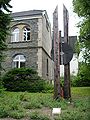
"Wiking II" by Stanislaw Kowalczyk (2004)


Village festival and club life
Once a year the traditional village festival is celebrated in the historic village, at which the volunteer fire brigade , the technical aid organization and most of the important associations such as TSV Gruiten 1884 e. V. or the amateur radio association . But the majority of the participating organizations are dedicated to nature conservation and the preservation of Gruiten's forests.
The club life in Gruiten is diverse: In addition to the TSV Gruiten for sports, numerous musical clubs are also represented. The men's choir Gruiten from 1906, the trombone choir of the ev.-ref. The parish and many others ensure a varied cultural life.
Important personalities
- Prelate Bernhard Marschall , 1934 to 1962 pastor of the cath. , Parish on March 1, 1953 honorary citizen appointed
- Paul Kratz (* 1878 at Gut Hermgesberg; † 1939), manager of the coal mining industry.
Economy and Transport
In the vicinity of the landscape protection area there is the Düsselberg industrial area , which extends over the streets Leichtmetallstraße, Düsselberger Straße, Thunbuschstraße and Fuhr. Medium-sized companies are located there, including a .:
- Discher Technik GmbH
- Europe teaching aids
- Rockwell Automation
- Fudickar lightweight construction
- Plant construction rammers
The Düsseldorf – Elberfeld line and the Haan-Gruiten – Cologne-Deutz line have a common stop at Haan-Gruiten station . There, S- Bahn Rhein-Ruhr and local trains run to the surrounding cities of Düsseldorf , Solingen and Wuppertal . In addition, the bus lines O1, 641, 742 run to the center of Haan and other places in the Mettmann district.
Web links
Individual evidence
- ^ Federal Statistical Office (ed.): Historical municipality directory for the Federal Republic of Germany. Name, border and key number changes in municipalities, counties and administrative districts from May 27, 1970 to December 31, 1982 . W. Kohlhammer, Stuttgart / Mainz 1983, ISBN 3-17-003263-1 , p. 293 .
- ↑ Surrender in Gruiten (accessed December 1, 2008)
- ↑ a b c Area changes Gruiten
- ^ Federal Statistical Office (ed.): Historical municipality directory for the Federal Republic of Germany. Name, border and key number changes in municipalities, counties and administrative districts from May 27, 1970 to December 31, 1982 . W. Kohlhammer, Stuttgart / Mainz 1983, ISBN 3-17-003263-1 , p. 293 .

Haan
Backesheide |
Bastianskotten |
Bech |
Bellekuhl |
Bollenheide |
Bottenberg |
Breidenmühle |
Brill |
Britten |
Bruchermühle |
Bushes |
Bush house |
Bushyards |
Diekermühle |
Bastard |
Driesch |
Ellscheid |
Elp |
Frabkenberg |
Goldberghäuschen |
Grünewald |
Reason |
Haanerkotten |
House |
Heidberg |
Heidfeld |
Henym |
Holthausen |
Horstmannsmühle |
Irdelen |
Kamp |
Cellar gate |
Obenklophausen |
Oberhaan |
Kamphausen |
Kriekhausen |
Kneading iron |
Reminds |
Mahnertmühle |
Titmouse |
Mullersberg |
Neighbor Mountain |
Pütt |
Pütterberg |
Putt dent |
Rodensiepen |
Sand |
Sand sieves |
Schaafenkotten |
Sound break |
Turnpike |
Schmachtenberg |
Schiensbusch |
Sömbers |
Spörkelbruch |
Stone house |
Steeg |
Fir grove |
Tenger |
Thienhausen |
Overfield |
Unterellscheid |
Untenklophausen |
Zwengenberg
Gruiten
Aue |
Bausenberger Busch |
Bäusenberg |
Birschels |
Bracken |
Bracker mill |
Broeckers |
Bread hedge |
Bruckerhöhe |
Bookcase |
Düsselberg |
Düsseler Mühle |
Düsseler jump |
Ehlenbeck |
Flachskamp |
Frinzhäuschen |
Drove |
Gathen |
Gellenkothen |
Groß Düssel |
Gruiten village |
Reason |
Goodness |
Habbach |
Hardenberg |
Rabbit house |
Hassiepen |
Heinhausen |
Heidersprung |
Hermgesberg |
Iselkull |
Jägerhof |
Kamp |
Kamperhütte |
Folding cap |
Konradsheide |
Lindenbeck |
Lamb |
Lohoff |
Pelzers |
Obgruits |
Osterholz |
Pfaffenhütte |
Polish hat |
Rose tree |
Schefenheide |
Sloping |
Straw cap |
Tuck coat |
Vockenhaus |
Voisheide |
Voosholz |
Weilenhaus |
Wusthofen |
Windfoche |
Brick house |
To the mills
Left:
Diepenbeck |
Isenberg |
Klevenhof |
Mühlenfeld |
Schlösserhütte |
Vogelsang