
Dortmund city fortifications


The Dortmund city fortifications were the historical, medieval city festivals of the free imperial city of Dortmund . The city fortifications were built around the historic city center after the fourth city expansion around 1200. The fortress consisted of a city wall, gates and towers and was 3.3 km in length. Between 1810 and 1874 the city wall was razed and the space that became free was redesigned into a promenade planted with rows of trees. Today, instead of the city wall, there is the six-lane Wallring, which is part of the federal highway 54 .
city wall
The actual city wall was built using the Romanesque two-shell technique. The original city wall was eight to nine meters high and had a heaped earth wall in the direction of the city, which was supported by a foot wall. In front of the city wall there was a moat with an average width of twelve to 18 meters. Behind this ditch was the front wall, which was five meters high. Before 1545 there was another moat and a path with a wooden palisade surrounding the town in front of this wall.
The fortification structure changed over time. In the middle of the 16th century the outer moat was filled in and the areas that became free were used as gardens.
The medieval city fortification is entered as a ground monument in the list of monuments of the city of Dortmund .
Gates and gates
The city wall, the imperial city of Dortmund, which was created at the intersection of two trade routes, originally had four city gates. The Kuckelketor is the oldest gate. The west and east gates were on Hellweg. The Wißstrasse Gate was in the south of the city. As part of the expansion of the city festivals, the Burgtor was added in the north and the Neutor and the Hövelpforte and Töllnerpforte in the southeast. The Töllnerpforte was located east of the Neutor, the Hövelpforte southeast of the Westentor. Both gates were closed again around 1380.
Kuckelketor

The Kuckelketor was in the north of the city. It was named after the Kuckelke brook, of which only one street can be remembered today. Here was also a pond where the witch trials , the water sample was performed. The city gate consisted of an almost square gate tower with a base area of eight by nine meters. In addition, there was a 13 meter long front structure and a bridge support. A drawbridge then spanned the moat.
The Kuckelketor had been in disrepair since 1742 and was demolished in 1806 as the first Dortmund city gate. Today there is a model of the city gate on the corner of Kuckelke / Burg- / Schwanenwall, the floor plan of the gate is drawn in the pavement.
West gate
The Westentor opens the city on Hellweg in the direction of Essen and Duisburg . The gate was first mentioned in 1292 as Porta Occidentalis ( Latin for western gate ). At this time Johann von Chrispin built the Jacobus Chapel in front of the west gate in the city center.
The west gate consisted of a gate tower that was level with the city wall. In front of it there were two staggered front structures, each with an upstream tower structure. In front of the northern porch was the wooden drawbridge over the outer moat.
Outside the west gate was the place of execution for the witch trials .
The West Gate was demolished in 1810. Today the Westentor underground railway station is located on the site of the West Gate.
Castle gate


The castle gate was located in the north of the city on the trade route in the direction of Münster and Bremen , today's Münsterstrasse. The castle gate was first mentioned in 1257 as Porta Urbis (city gate). After 1298 the Latin name Porta Castris (castle gate) is found. It was named after the nearby royal castle .
The gate consisted of a gate tower, a forecourt and the drawbridge spanning the moat. The red and white city flag of the city of Dortmund waved on the gate tower.
The castle gate existed until 1833.
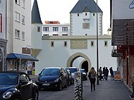
Ostentor
The Ostentor was on Hellweg on the trade route towards Soest , Lippstadt and Paderborn . The Ostentor is first mentioned in the town charter recorded from 1255 to 1256. The Latin name Porta Orientalis is also used for the Ostentor . The Benedictine chapel was attached to the gate . With a length of over 50 meters, it was the longest gate castle in the city and spanned both moats. The following inscription was attached to the gate: "Dus stat is vry, to whom ryke fetches, verkoept des nicht umb everything." ( This city is free, loyal to the rich , don't sell that for all gold )
The Ostentor consisted of a gate tower and an outer structure. Around 1520 the Ostentor was expanded and two corner towers were integrated into the outer structure as guard houses. Demolition was considered for the first time in 1772 due to the structural condition, but in 1780 it was decided to renew the roof in a simplified form. In 1810 the gate was actually demolished. In contrast to the other gates, the Ostentor has been given a true-to-scale floor plan.
Today there is an intersection of the same name and the underground Ostentor underground station of the Dortmund Stadtbahn . The artistic design of the underground station revolves around the subject of Dortmund city fortifications.
- Reconstruction of the Ostentor (after Heinrich Scholle)
seen from Kaiserstraße

seen from the Schwanenwall
.jpg)
.jpg)
Neutor

The new gate, also called new gate, was located in the southeast of the city wall. The gate was built in 1320 and secured the trade route to the Brandenburg cities of Hörde , Schwerte and Altena . It is shown in the city view from the south of Derick Baegert on the altarpiece in the provost church from 1475.
This structure also consisted of a gate tower, fortified front works and a drawbridge and was less fortified.
The new gate was demolished at the height of the city wall in 1804 and completely razed in 1810.
Wissstrasse Gate
The Wißstrasse Gate was first mentioned in 1359 with the Latin name Porta Wysstrate . From the altarpiece by Derick Baegert in the provost church, the oldest pictorial representation of the city, the Wißstrasse gate was still depicted as a classic city gate. At the end of the 16th century, the gate was converted into a bastion . The pentagonal complex was at the highest point of the city fortifications and watched over the trade route that led to Cologne . Two drawbridges are guaranteed for the Wißstraßentor in 1689. In the great Dortmund feud and in the betrayal of the city by Agnes von der Vierbecke , the city gate was of particular importance. The Wißstrasse Gate was the last of the Dortmund city gates to be demolished in 1851. During an archaeological excavation in 1993 as part of the construction of a new underground car park, the remains of the wall and foundations of the gate were found.
The Windmühlenberg and the Windmill
Until 1874, the Windmühlenberg stood on the high wall between the Westen- and Wißstraßentor. It belonged to the Dortmund city wall and dented in a semicircular shape within the city fortifications. On top was an octagonal Dutch windmill with a rotating hood. It is not listed on Diedrich Mulher's city map from 1611, so it must have been built later. This location was chosen because Windmühlenberg and high wall were higher than the rest of the city and provided the best wind conditions. In 1874 the last remnants of the old city wall from the Wißstraßentor to the Windmühlenberg were demolished, including the windmill.

Reconstruction of the windmill on the Windmühlenberg and the city wall with the Wißstrasse gate at the top around 1772.

Reconstruction of the windmill on the Windmühlenberg from the south side around 1803. The red tower on the right has already been demolished except for the city wall.
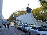
Virtual reconstruction of the Windmühlenberg in today's cityscape on the Hohen Wall.

Virtual reconstruction of the Windmühlenberg and the red tower to the east in today's cityscape (after Heinrich Scholle).


Watchtowers
The total of 14 towers of the Dortmund city fortifications were built after the construction of the city wall. They were used for military protection and were primarily used as watchtowers. Sometimes the towers were also used as warehouses or as a prison. The average distance between the towers was 200 meters.
Snake tower
The snake tower was located between the Ostentor and the Kuckelketor. The tower, also known as the "Turm am Gänsemarkt", was first found in 1570 in the pictorial representation of Braun and Hogenberg. The tower had a square base of 36 m². The snake tower was demolished in 1832.
Swan tower
The swan tower was also located between the Ostentor and the Kuckelketor. It had a square floor plan of 49 m² and can already be found in the pictorial representation of Braun and Hogenberg.
The tower was demolished in 1832. The swan wall is named after the swan tower.
Hell tower
The Hell Tower was located between the Kuckelketor and the Burgtor. The tower is depicted differently in the various historical pictorial representations of the city. There are rectangular, triangular and semicircular representations of the tower. The tower was not far from today's street Helle.
The tower was demolished around 1800.
Catherine Tower
The Katharinenturm was built in 1480 and at times also served as a prison.
In 1830 it was used as a powder tower . The tower was not demolished until between 1860 and 1876.
Reifschlägerturm

The Reifschlägerturm, also Repschlägerturm or Martinsturm, was located between the Wißstraßentor and the Neutor on the south wall. He is shown on the city view from the south of Derick Baegert 1475 between the two gates. According to the ground plan in the original cadastre from 1826, the tower had a diameter of 12.50 m. The City view of Benedict Anton Berger shows the tower in 1804 still intact, according to one of Tempeltey lithographed drawing of Borchel the tower was demolished in 1860 to the level of the city wall.
Eagle tower
Today's Adlerturm is a reconstructed tower that was erected in 1992 over the original foundations of the former defense tower. The 30-meter-high tower was placed on pillars so as not to impair the structure of the foundations of the original 14th-century eagle tower and the adjoining city wall.
Palm tower
The palm tower resembled the eagle tower in its semicircular floor plan. He stood in the wall section between Neutor and Ostentor and there between Adlerturm and Judenturm. According to the original cadastre of 1826, it had a diameter of 11 m. The tower was built from 1527. It was also referred to as the foremost powder tower, as it was in front of the rearmost powder tower when the sun was shining, the parade ground for the citizens.
Waiting and guard houses
Stone tower
The stone tower is a historic watch tower in Dortmund not far from the Westfalenhallen . It was part of the military defenses of the medieval imperial city and the city fortifications of the historic city center. The watchtower controlled the long-distance trade route leading south from Dortmund to Cologne. It stands on the historical boundary of the Stadthagens , which has existed since the 13th century , the territory in front of the fortified city, in which municipal law applied. The stone tower is located 2.5 kilometers south of the ramparts.
Fredenturm
The Fredenturm was a watchtower north of the city. It was thus the counterpart to the stone tower to the south. A signal system was installed on the Fredenturm, with which the city could be informed of danger by means of optical signals over a greater distance.
Listener wait
The Hörder waiting was in the Landwehr integrated waiting on the southern border of the county Dortmund . It was located on the Emscher at the transition to the Hörde in the county of Mark .
See also
literature
- Christiane Althoff: The fortification of the city of Dortmund. Results of the city core archeology . P-und-R-Verlag, Dortmund 1996, ISBN 3-930504-00-7 ( formally incorrect ) .
- Karl Neuhoff: Dortmund's art of fortification and its limits . Krüger, Dortmund 1994, ISBN 3-927827-04-5 .
Web links
Individual evidence
- ↑ No. B 0002. List of monuments of the city of Dortmund. (PDF) (No longer available online.) In: dortmund.de - Das Dortmunder Stadtportal. Monument Authority of the City of Dortmund, April 14, 2014, archived from the original on September 15, 2014 ; accessed on June 12, 2014 (size: 180 kB). Info: The archive link was inserted automatically and has not yet been checked. Please check the original and archive link according to the instructions and then remove this notice.
- ^ A b Heinrich Scholle: Dortmund in 1610 . In: Gustav Luntowski and Norbert Reimann (eds.): Monographs on the history of Dortmund and the county of Mark . tape 9 . Verlag des Historisches Verein Dortmund, Dortmund 1987, p. 33 .