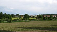
Drausendorf
|
Drausendorf
City of Zittau
Coordinates: 50 ° 55 ′ 21 ″ N , 14 ° 51 ′ 58 ″ E
|
|
|---|---|
| Height : | 227 m above sea level NN |
| Residents : | 140 (March 31, 2016) |
| Incorporation : | May 19, 1974 |
| Incorporated into: | Hirschfelde |
| Postal code : | 02788 |
| Area code : | 035843 |
|
Location of Drausendorf in the area of the city of Zittau
|
|
Drausendorf is a district of Zittau in south-east Saxony . It lies on the border with Poland in the Görlitz district . Until it was incorporated into Hirschfelde in 1974, Drausendorf was an independent municipality.
Location and surroundings
Drausendorf is about four kilometers northeast of Zittau and 2.7 km southwest of Hirschfelde. In the east the place borders on the Lusatian Neisse and thus on the Republic of Poland . In the west, the federal highway 99 forms the end. Until the 1990s, Drausendorf had a stop on the Neißetalbahn . In Drausendorf the Wittgendorfer Wasser flows into the Neisse , south of the Scheidebach . The Oder-Neisse cycle path leads through the village .
history
The first documentary mention of Drausendorf is in 1366. Initially called "Drusendorff", the place can be found a few years later in the foundation charter of Emperor Charles IV for the Oybin monastery in 1369 as "Drozendorff". This name is a mixture of the Old Sorbian personal name "Druž" and the German "Dorf". In 1546 Drausendorf was pledged to the city of Zittau and sold in full in 1574. It was the oldest estate in the city of Zittau. In 1805 a first brown coal mine was built near the village. However, the coal produced was of poor quality. Unfavorable mining conditions initially prevented an economic upturn. With industrialization, new technology was introduced in the mining process, so that in the neighboring villages of Türchau and Gießmannsdorf after 1904, coal production was steadily expanded. In this context, the Herkules lignite plant was built in Hirschfelde in 1908, followed by a large-scale power plant in 1911 , which soon developed into the heart of the Saxon energy supply and became the main employer for many residents of Drausendorf. Other residents found wages and bread, for example, in the Hirschfeld textile factories and in nearby Zittau. After 1950, several apartment buildings were built in the village for the workers. After 1945 the Neisse became the border. On the Polish side, the Turów power plant was put into operation in 1962 ; the coal for this is still supplied by the Turów opencast mine , which reached a depth of 225 meters in 2003 and is to be expanded to a depth of 300 meters. The distance from the edge of the opencast mine to the village of Drausendorf is so small that there have been repeated building damage in the village due to ground movements. In addition to the lignite industry, the LPG 10th anniversary of the GDR became an important employer in the town after 1945 .
Despite Poland joining Schengen in December 2007, the Neisse bridge remained closed as a border crossing due to a lack of funds for rehabilitation. On the German side, the access was dredged away as part of a flood protection measure (2008–2009). The city of Zittau and the Free State of Saxony reached an agreement in January 2011 to demolish the bridge, and the Free State of Saxony assumed the costs of the demolition.

On May 19, 1974, Drausendorf was incorporated into Hirschfelde and incorporated into Zittau on January 1, 2007 together with Hirschfelde.
The devastating flood of August 7, 2010 damaged almost all buildings in the village, some of them irreparably.
Attractions
- Vorwerk Drausendorf with mansion
- Alder forest and old English oaks on an old pond area
- original river and meadow landscape
- House of the estate shepherd from the 17th century, a two-storey block building with surrounding framework
literature
- The south-eastern Upper Lusatia with Zittau and the Zittau Mountains (= values of the German homeland . Volume 16). 1st edition. Akademie Verlag, Berlin 1970, p. 132f.
- Carl Gottlob Moráwek : History of Drausendorf near Zittau . Zittau 1873 ( digitized version )
- Gotthelf Traugott Eckarth: Chronica, or: historical description of the Drausendorff village between Zittau and Hirschfeldau . Zittau 1752 ( digitized version )
Web links
- Web presence of the city of Zittau
- Drausendorf at hirschfelde.de
- Drausendorf in the Digital Historical Directory of Saxony
- CFT Rudowsky: Directory of the entire localities of the Kingdom of Saxony ... after the census on December 3, 1855. Ramming, Dresden 1857, p. 13.
Individual evidence
- ↑ Stadtanzeiger No. 281 (April 2016). (PDF; 2.1 MB) Zittau city administration, April 10, 2016, archived from the original on April 19, 2016 ; Retrieved April 19, 2016 .
- ↑ Saxony is tearing down border bridges. Sächsische Zeitung , January 29, 2011, accessed on January 30, 2011 (The Free State has agreed to take over the demolition of four blocked Neisse bridges and remnants of bridges in Zittau. The city and the state have now agreed on this State dam administration (LTV) takes care of the four bridges, for which the city of Zittau and the city of Bogatynia no longer see any use, "said Zittau's mayor Michael Hiltscher (CDU) yesterday when asked. [...] .
- ↑ Municipalities 1994 and their changes since January 1, 1948 in the new federal states , Metzler-Poeschel publishing house, Stuttgart, 1995, ISBN 3-8246-0321-7 , publisher: Federal Statistical Office
- ^ Area changes from January 1, 2007 to December 31, 2007. (PDF; 13 kB) State Statistical Office of the Free State of Saxony , p. 1 , accessed on January 5, 2013 .
