Eisenbach (Gelbach)
| Eisenbach | ||
|
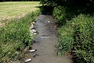
The Eisenbach in the municipality of Heilberscheid |
||
| Data | ||
| Water code | DE : 258946 | |
| location |
Westerwald
|
|
| River system | Rhine | |
| Drain over | Gelbach → Lahn → Rhine → North Sea | |
| source | near Ehringhausen (district of Meudt ) 50 ° 30 ′ 52 ″ N , 7 ° 54 ′ 3 ″ E |
|
| Source height | approx. 380 m above sea level NHN | |
| muzzle | near Reckenthal ( Montabaur ) in Gelbach Coordinates: 50 ° 25 '11 " N , 7 ° 52' 24" E 50 ° 25 '11 " N , 7 ° 52' 24" E |
|
| Mouth height | approx. 180 m above sea level NHN | |
| Height difference | approx. 200 m | |
| Bottom slope | approx. 12 ‰ | |
| length | 16.9 km | |
| Catchment area | 40.056 km² | |
The Eisenbach is a sixteen kilometer long and left tributary of the Gelbach near Reckenthal ( Montabaur ). It flows through the Rhineland-Palatinate Westerwaldkreis .
geography
course
The Eisenbach rises in the Montabaur valley near Ehringhausen (municipality of Meudt ) in the northeastern part of the community of Wallmerod . From here it flows southeast to Berod near Wallmerod and from here at Steinefrenz runs south and enters the municipality of Girod . From here it turns to the southwest, past the Girod district of Kleinholbach , and then serves as the border between Nomborn and the southwestern municipality of Girod. Flowing further to the southwest, the river reaches the northeastern municipal area of Heilberscheid and then joins the Gelbach from the left at Reckenthal (district of Montabaur ) .
Tributaries
- Meudter Bach (from the right, east of Meudt, approx. 2 km, GKZ 25894612)
- Lochheimer Bach (from the left, north of Berod, approx. 3 km, GKZ 2589462)
- Quallbach (from the right, north of Zehnhausen, approx. 2 km, GKZ 25894632)
- Zehnhausener Wiesenbach (from the right, south of Zehnhausen, approx. 850 m, GKZ 258946392)
- Leckersbach (from the left, north of Steinefrenz, approx. 2.5 km, GKZ 2589464)
- Rother Bach (from the right, east of Steinefrenz, approx. 3.6 km, GKZ 2589466)
- Schuldheissener Mühlengraben (junction, to the right, southeast of Steinefrenz, 777 m, GKZ 258946714)
- Giroder Dorfbach (from the right, south of Girod, approx. 2.3 km, GKZ 2589468)
- Bach from Kleinholbach (from the right, near Kleinholbach, 1.2 km, GKZ 258946914)
- Graben von der Freimühle (junction, from the right, south of Kleinholbach, 650 m, GKZ 2589469172)
- Nomborn (from the left, northwest of Nomborn, 860 m, GKZ 258946918)
Trivia
The Eisenbach gives its name to the Eisbachtaler Sportfreunde sports club , which uses an abbreviation of the Eisenbach name for its name.
Web links
Individual evidence
- ↑ a b topographic-map.com
- ↑ a b Rhineland-Palatinate Water Management Authority
- ↑ dfb.de: Weidenfeller. From the Westerwald out into the world of football. Retrieved July 2, 2020


