Eordea
|
Municipality of Eordea Δήμος Εορδαίας (Εορδαία) |
||
|---|---|---|
|
|
||
| Basic data | ||
| State : |
|
|
| Region : | Western Macedonia | |
| Regional District : | Kozani | |
| Geographic coordinates : | 40 ° 32 ' N , 21 ° 45' E | |
| Area : | 708.807 km² | |
| Residents : | 45,592 (2011) | |
| Population density : | 64.3 inhabitants / km² | |
| Seat: | Ptolemaida | |
| LAU-1 code no .: | 1403 | |
| Districts : | 5 municipal districts | |
| Local self-government : |
1 city district 25 local communities |
|
| Website: | www.ptolemaida.gr | |
| Location in the West Macedonia region | ||
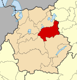
Eordea ( Greek Εορδαία ) is a municipality in the east of the Greek region of Western Macedonia . The administrative seat of the municipality is the city of Ptolemaida.
Apart from minor deviations in the north and south-east, the municipality almost corresponds to the extent of the former province of Eordea.
location
The municipality of Eordea is located in the east of the Western Macedonia region. In the east, the Vermio forms the natural border with the municipalities of Noussa and Veria in the neighboring region of Central Macedonia . In the south is the municipality of Kozani . In the west, the two mountain ranges of Verno and Siniatsik form the border with the municipalities of Voio , Argos Orestiko and Kastoria . To the north is Amyndeo .
Administrative division
The municipality was formed after the administrative reform in 2010 from the merger of the former municipalities Ptolemaida , Agia Paraskevi , Vermio and Mouriki as well as the rural municipality Vlasti . The administrative seat of the municipality is Ptolemaida. The former municipalities have since formed municipal districts. The municipality is further subdivided into the municipality of Ptolemaida and 25 local communities.
| Parish | Greek name | code | Area (km²) | Residents 2011 | City district / local communities (Δημοτική / Τοπική Κοινότητα) |
location |
|---|---|---|---|---|---|---|
| Ptolemaida | Δημοτική Ενότητα Πτολεμαΐδας | 140301 | 217,901 | 37,289 | Ptolemaida, Asvestopetra, Galatia, Drosero, Kardia, Komanos, Mavropigi, Olymbias, Pendavrysos, Perdikkas, Palia Ambelia, Pteleonas | |
| Agia Paraskevi | Δημοτική Ενότητα Αγίας Παρασκευής | 140302 | 119.606 | 1,352 | Agios Christoforos, Ermakia, Karyochori, Spilia | |
| Vermio | Δημοτική Ενότητα Βερμίου | 140303 | 187.153 | 2,768 | Anatoliko, Komnina, Mesovouno, Pyrgi | |
| Vlasti | Δημοτική Ενότητα Βλάστης | 140304 | 72,089 | 274 | Vlasti | |
| Mouriki | Δημοτική Ενότητα Μουρικίου | 140305 | 112.058 | 3,909 | Anarrachi, Ardassa, Emborio, Mylochori, Foufas | |
| total | 1403 | 708,807 | 45,592 | |||
Individual evidence
- ↑ Results of the 2011 census at the National Statistical Service of Greece (ΕΛ.ΣΤΑΤ) (Excel document, 2.6 MB)
- ↑ Kallikratis Program, Law 3852/2010, «Νέα Αρχιτεκτονική της Αυτοδιοίκησης και της Αποκεντρωμένης ΔιοκεντρωμΠνης Διοίκησης - Πρόγραμημα άρτάτης τρτάτης. ΦΕΚ 87 A / 7.6.2010, Άρθρο 1. Σύσταση δήμων. P. 1790. PDF Online (Greek)


