
Voio (municipality)
|
Municipality of Voio Δήμος Βοΐου (Βόιο) |
|||
|---|---|---|---|
|
|||
| Basic data | |||
| State : |
|
||
| Region : | Western Macedonia | ||
| Regional District : | Kozani | ||
| Geographic coordinates : | 40 ° 19 ′ N , 21 ° 23 ′ E | ||
| Area : | 1,021.02 km² | ||
| Residents : | 18,386 (2011) | ||
| Population density : | 18 people / km² | ||
| Seat: | Siatista | ||
| LAU-1 code no .: | 1402 | ||
| Districts : | 5 municipal districts | ||
| Local self-government : |
3 city districts 56 local communities |
||
| Website: | dimosvoiou.gr | ||
| Location in the West Macedonia region | |||
 |
|||

Voio ( Greek Βόιο ( n. Sg. )) Is a municipality in the Greek region of Western Macedonia. It takes its name from the mountain range of Voio in the Pindos Mountains towering to the west . The administrative seat is the small town Siatista (5490 Ew.), Other larger settlements are Neapoli (2285 Ew.), Galatini (1795 Ew.), Tsotyli (1545 Ew.) And Eratyra (1097 Ew.). Of the 68 still inhabited settlements, only nine still have a population of over 200.
The villages and settlements of Voio were administered in the late Ottoman Empire in Kaza Nasliç by today's Neapoli (at that time in Greek Anaselitsa Ανασελίτσα or Liapsisti Λιαψίστι), which in the Kingdom of Greece after 1913 the province of Anaselitsa, reduced by a few villages , from 1926 Province of Voio, as an administrative unit followed. From 1997 to 2010, when the province was abolished, the villages formed five municipalities; they were merged in 2011 to form the municipality of Voio.
geography

The municipality covers the southeastern part of the eponymous mountain massif Voio , whose highest peak ( 1805 m ) is on the border between the neighboring communities Nestorio (west) and Argos Orestiko (north). The low mountain range Voio, whose peaks on the western edge of the municipality still reach 1760 m , is one of the most densely forested areas in Greece, is sparsely populated and is the habitat of rare predatory species such as wolves , bears and wild cats . The also forested plateau of the Megala Ondria (Mεγάλα Όντρια, up to 1589 m ) in the northeast of the municipality near Zoni is almost untouched by steep rocky slopes to the surrounding area. The eastern slope of the Voio massif drops about 20 kilometers east to the valley of the Aliakmonas , which crosses the municipality in a north-south direction and to which numerous streams from the Voio flow.
To the east of the Aliakmonas rise two mountain ranges, which shield the municipality to the east from the municipalities of Eordea and Kozani : north of the Siniatsiko or Askio (with 2111 m the highest point in the municipality), south of it the Vourinos with the Drisinikos ( 1866 m ) on the Border to the southern neighboring municipality of Grevena . The Aliakmonas leaves the Voios area at about 500 m above sea level in the extreme southeast on the western slope of the Vourinos.
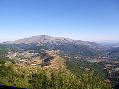
The Askio from the northeast

Former town hall in Pendalofos
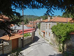
Polykastano

Pelekanos


population
Even before the Balkan Wars and the population exchange between Greece and Turkey after 1923, a Greek-speaking majority lived in the Voios area. A considerable part of the Greeks, however, were Muslim; these residents were relocated to Turkey under the Treaty of Lausanne . The Slavic-speaking villages belonged to the Patriarchate of Constantinople , so they were Greek Orthodox, as were the Aromanians (mainly in Sisani and Pipelište, today's Namata). There were Roma minorities in Anaselitsa and Tsotyli .
The population of the province of Anaselitsa after the population exchange is documented in the Greek census of 1928, which also recorded the place of birth and native language of the inhabitants. According to this, 34,652 people lived in the province, of whom 29,919 were born in Greece and 4,733 outside Greece (1883 in Asia Minor, 2177 on the Black Sea and 410 in non-Greek Thrace and Constantinople). The main mother tongues were Greek (33,334 people) and Turkish (917), as well as “Macedonoslavian” (257) and Koutzovlachian (113).
Infrastructure
Siatista is not far from the Greek A 2 , which is the most important west-east road connection in northern Greece and passes the municipality in the south. From here the A 29 branches off , which leads north from Siatista to Kastoria. The older National Road 15 runs parallel to it; National Road 20 also runs west-east through the municipality and connects the municipality with Ioannina on the west side of the Pindus. The nearby communities of Argos Orestiko and Kozani have small airports with little traffic and there is no rail link.
Community structure
The 59 municipalities that were independent until 1997 now form urban districts (Ez. Gr. Dimotiki kinotita, for places with more than 2,000 inhabitants) or local communities (Ez. Topiki kinotita ), which elect their own local representatives. The population figures come from the results of the 2011 census.

- Askio Municipality - Δημοτική Ενότητα Ασκίου - 4,002
- Galatini District - Δημοτική Κοινότητα Γαλατινής - Γαλατινή - 1.795
- Local community Eratyra - Τοπική Κοινότητα Ερατύρας - Εράτυρα - 1.097
- Local community Kaloneri - Τοπική Κοινότητα Καλονερίου - Καλονέρι - 483
- Local community Namata - Τοπική Κοινότητα Ναμάτων - Νάματα - 104
- Local community Pelekanos - Τοπική Κοινότητα Πελεκάνου - Πελεκάνος - 269
- Local community Sisani - Τοπική Κοινότητα Σισανίου - Σισάνι - 254

- Municipality of Neapoli - Δημοτική Ενότητα Νεάπολης - 4.100
- Municipality of Neapoli - Δημοτική Κοινότητα Νεάπολης - 2,323
- Melidoni - Μελιδόνι - 38
- Neapoli - Νεάπολη - 2.285
- Local community Aidochori - Τοπική Κοινότητα Αηδονοχωρίου - 89
- Aidochori - Αηδονοχώρι - 45
- Kallistrati - Καλλιστράτι - 44
- Local community Aliakmonas - Τοπική Κοινότητα Αλιάκμονος - Αλιάκμονας - 231
- Local community Asproula - Τοπική Κοινότητα Ασπρούλας - 122
- Asproula - Ασπρούλα - 76
- Kryoneri - Κρυονέρι - 46
- Local community Axiokastro - Τοπική Κοινότητα Αξιοκάστρου - 133
- Axiokastro - Αξιόκαστρο - 36
- Climate - Κλήμα - 97
- Local community Chimerino - Τοπική Κοινότητα Χειμερινού - Χειμερινό - 50
- Local community Chorigos - Τοπική Κοινότητα Χορηγού - 90
- Chorigos - Χορηγός - 90
- Panagia - Παναγία - uninhabited
- Local community Dryovouno - Τοπική Κοινότητα Δρυοβούνου - Δρυόβουνο - 251
- Local community Lefkothea - Τοπική Κοινότητα Λευκοθέας - Λευκοθέα - 20
- Local community Mesolongos - Τοπική Κοινότητα Μεσολόγγου - Μεσόλογγος - 40
- Local community Molocha - Τοπική Κοινότητα Μολόχας - Μολόχα - 132
- Local community Peponia - Τοπική Κοινότητα Πεπονιάς - Πεπονιά - 70
- Local community Peristera - Τοπική Κοινότητα Περιστέρας - Περιστέρα - 22
- Local community Platania - Τοπική Κοινότητα Πλατανιάς - Πλατανιά - 93
- Local community Polylakko - Τοπική Κοινότητα Πολυλάκκου - Πολύλακκο - 29
- Local community Pylori - Τοπική Κοινότητα Πυλωρίου - Πυλωρί - 57
- Local community Simandro - Τοπική Κοινότητα Σημάντρου - Σήμαντρο - 38
- Local community Skalochori - Τοπική Κοινότητα Σκαλοχωρίου - Σκαλοχώρι - 102
- Local community Trapezitsa - Τοπική Κοινότητα Τραπεζίτσης - 99
- Panareti - Παναρέτη - 22
- Trapezitsa - Τραπεζίτσα - 77
- Local community Velanidia - Τοπική Κοινότητα Βελανιδιάς - 109
- Sterna - Στέρνα - 30
- Velanidia - Βελανιδιά - 79
- Municipality of Neapoli - Δημοτική Κοινότητα Νεάπολης - 2,323

- Pendalofos parish - Δημοτική Ενότητα Πενταλόφου - 620
- Local community Agia Sotira - Τοπική Κοινότητα Αγίας Σωτήρας - Αγία Σωτήρα - 28
- Local community Dilofo - Τοπική Κοινότητα Διλόφου - Δίλοφο - 24
- Local community Pendalofos - Τοπική Κοινότητα Πενταλόφου - Πεντάλοφος - 446
- Local community Vythos - Τοπική Κοινότητα Βυθού - Βυθός - 122

- Siatista parish - Δημοτική Ενότητα Σιάτιστας - 6,247
- Siatista Municipality - Δημοτική Κοινότητα Σιατίστης - Σιάτιστα - 5,490
- Local community Mikrokastro - Τοπική Κοινότητα Μικροκάστρου - 446
- Mikrokastro - Μικρόκαστρο - 420
- Moni Kimiseos Theotokou Mikrokastrou - Μονή Κοιμήσεως Θεοτόκου Μικροκάστρου - 26
- Local community Paleokastro - Τοπική Κοινότητα Παλαιοκάστρου - 311
- Dafnero - Δαφνερό - 72
- Paleokastro - Παλαιόκαστρο - 239

- Tsotyli municipality - Δημοτική Ενότητα Τσοτυλίου - 3,417
- Local community Agiasma - Τοπική Κοινότητα Αγιάσματος - 52
- Agiasma - Αγίασμα - 3
- Agios Theodoros - Άγιος Θεόδωρος - 34
- Achladea - Αχλαδέα - 12
- Kiladi - Κοιλάδι - 3
- Local community Agii Anargyri - Τοπική Κοινότητα Αγίων Αναργύρων - Άγιοι Ανάργυροι - 37
- Local community Anthousa - Τοπική Κοινότητα Ανθούσης - 42
- Anthousa - Ανθούσα - 30
- Triada - Τριάδα - 12
- Local community Anthochori - Τοπική Κοινότητα Ανθοχωρίου - 136
- Anthochori - Ανθοχώρι - 98
- Fytoki - Φυτώκι - 38
- Parochthio - Παρόχθιο - uninhabited
- Local community Avgerinos - Τοπική Κοινότητα Αυγερινού - Αυγερινός - 236
- Local community Chrysavgi - Τοπική Κοινότητα Χρυσαυγής - Χρυσαυγή - 102
- Local community Dafni - Τοπική Κοινότητα Δάφνης - Δάφνη - 31
- Local community Damaskinia - Τοπική Κοινότητα Δαμασκηνιάς - Δαμασκηνιά - 152
- Local community Dichimarro - Τοπική Κοινότητα Διχειμάρρου - Διχείμαρρο - 50
- Local community Dragasia - Τοπική Κοινότητα Δραγασιάς - Δραγασιά - 50
- Local community Klisoria - Τοπική Κοινότητα Κλεισωρείας - Κλεισώρεια - 44
- Local community Koryfi - Τοπική Κοινότητα Κορυφής - Κορυφή - 70
- Local community Krimini - Τοπική Κοινότητα Κριμηνίου - Κριμήνι - 45
- Local community Liknades - Τοπική Κοινότητα Λικνάδων - 27
- Lefki - Λεύκη - 11
- Liknades - Λικνάδες - 16
- Local community Loukomi - Τοπική Κοινότητα Λουκομίου - Λουκόμι - 47
- Local community Louvri - Τοπική Κοινότητα Λούβρης - Λούβρη - 51
- Local community Morfi - Τοπική Κοινότητα Μόρφης - Μόρφη - 74
- Local community Omali - Τοπική Κοινότητα Ομαλής - 98
- Glykokerasia - Γλυκοκερασιά - 35
- Omali - Ομαλή - 63
- Local community Plakida - Τοπική Κοινότητα Πλακίδας - Πλακίδα - 10
- Local community Polykastano - Τοπική Κοινότητα Πολυκαστάνου - Πολυκάστανο - 120
- Local community Rodochori - Τοπική Κοινότητα Ροδοχωρίου - Ροδοχώρι - 52
- Local community Stavrodromi - Τοπική Κοινότητα Σταυροδρομίου - Σταυροδρόμι - 70
- Local community Tsotyli - Τοπική Κοινότητα Τσοτυλίου - 1.545
- Rokastro - Ρόκαστρο - uninhabited
- Tsotyli - Τσοτύλι - 1,545
- Local community Vouchorina - Τοπική Κοινότητα Βουχωρίνας - Βουχωρίνα - 35
- Local community Vrondi - Τοπική Κοινότητα Βροντής - 178
- Apidea - Απιδέα - 33
- Lefkadi - Λευκάδι - 22
- Vrondi - Βροντή - 123
- Local community Zoni - Τοπική Κοινότητα Ζώνης - Ζώνη - 63
- Local community Agiasma - Τοπική Κοινότητα Αγιάσματος - 52
Individual evidence
- ↑ a b Results of the 2011 census at the National Statistical Service of Greece (ΕΛ.ΣΤΑΤ) ( Memento from June 27, 2015 in the Internet Archive ) (Excel document, 2.6 MB)
- ↑ Portrait of the mountains of the West Macedonia region ( Memento of the original from July 28, 2014 in the Internet Archive ) Info: The archive link was automatically inserted and not yet checked. Please check the original and archive link according to the instructions and then remove this notice. on www.visitwestmacedonia.gr (gr.)
- ↑ Collection of material on the population of the villages in the area of Dimitri Lithoxoou, accessed on May 25, 2014 (Greek)
- ↑ Results of the Greek population censuses from 1879–2001, available as PDF under http://dlib.statistics.gr/portal/page/portal/ESYE/categoryyears?p_cat=10007862&p_topic=10007862
- ↑ Greek Law Gazette No. 1292 of August 11, 2010 (PDF, 555 KB)