
Fajsz (place)
| Fajsz | |||||
|
|||||
| Basic data | |||||
|---|---|---|---|---|---|
| State : | Hungary | ||||
| Region : | Southern Great Plain | ||||
| County : | Bács-Kiskun | ||||
| Small area until December 31, 2012 : | Kalocsa | ||||
| District since 1.1.2013 : | Kalocsa | ||||
| Coordinates : | 46 ° 25 ' N , 18 ° 55' E | ||||
| Area : | 31.99 km² | ||||
| Residents : | 1,667 (Jan 1, 2011) | ||||
| Population density : | 52 inhabitants per km² | ||||
| Telephone code : | (+36) 78 | ||||
| Postal code : | 6352 | ||||
| KSH kódja: | 03230 | ||||
| Structure and administration (status: 2018) | |||||
| Community type : | local community | ||||
| Mayor : | Zsolt Berta (independent) | ||||
| Postal address : | Szent István u. 20 6352 Fajsz |
||||
| Website : | |||||
| (Source: A Magyar Köztársaság helységnévkönyve 2011. január 1st at Központi statisztikai hivatal ) | |||||


Fajsz ( Croatian Fajsin ) is a Hungarian community in the county Kalocsa in Bács-Kiskun .
Geographical location
Fajsz is located 13 kilometers south of the town of Kalocsa on the left bank of the Danube . Neighboring communities are Dusnok and Bátya .
Parish partnership
Attractions
- Fajsz Monument
- Roman Catholic Church Szent István király , built in 1910 in neo-Romanesque style according to plans by Ernő Foörk and Gyula Petrovácz
- Fájdalmas Szűz Roman Catholic Chapel in the cemetery
- Szent Erzsébet statue
traffic
The main road No. 53 runs east of the municipality. The nearest train station is in Kalocsa.
literature
- Fajsz - Településképi Arculati Kézikönyv 2017. Ed. By the municipal administration.
photos
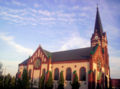
Roman Catholic Church of Szent István király

Entrance to the church

Fajsz monument

Local government


