Falgueyrate
| Falgueyrate | ||
|---|---|---|
|
|
||
| local community | Plaisance | |
| region | Nouvelle-Aquitaine | |
| Department | Dordogne | |
| Arrondissement | Bergerac | |
| Coordinates | 44 ° 41 ′ N , 0 ° 32 ′ E | |
| Post Code | 24560 | |
| Former INSEE code | 24173 | |
| Incorporation | 1st January 1973 | |
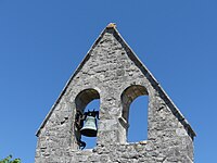
 Parish Church of Saint-Jean |
||
Falgueyrat is a former French commune of last 62 inhabitants (1968) in the department of Dordogne in the region Nouvelle-Aquitaine (before 2016: Aquitaine ).
On January 1, 1973, the former parishes Falgueyrat, Mandacou and Eyrenville merged to form the newly created parish Plaisance , with the former parishes being given the status of a Commune associée . The main town of Plaisance was Eyrenville. By resolution after the referendum on January 17, 2010, the merger was transformed into a simple merger of the three communes associées , in which the former municipalities were integrated into Plaisance.
geography
Falgueyrat is located about 20 km south-southeast of Bergerac in the Bergeracois area of the historic province of Périgord .
history
The village was once subordinate to Calech, which is now a hamlet of Saint-Aubin-de-Cadelech . The area was dependent on the manorial rule of Cahuzac . At the end of the Middle Ages , Falgueyrat, like Eyrenville, belonged to the diocese of Sarlat .
Toponymy
The name of the place is derived from the Occitan falguieràs ( German ferns ), which comes from the Latin filicaria .
Toponyms and mentions of falgueyrate were:
- Falgayrac ( copy book of the Abbey of La Sauve-Majeure ),
- Hospitale de Falgueyraco (1282, documents of the Order of Malta ),
- Falgayracum (1554, shield of the dioceses of Périgueux and Sarlat ),
- Falgueyret (map of Belleyme),
- Falgueyrac (1750 and 1793, map by Cassini or Notice Communale ),
- Falgueyrat (1801, Bulletin des Lois ),
- Falgayrac (1873, Dictionnaire topographique du département de la Dordogne).
Population development
At the beginning of the records, the population was a high of 380. In the following period the population fell to around 60 during short recovery phases until the community was dissolved.
| year | 1962 | 1968 |
|---|---|---|
| Residents | 91 | 62 |

Source: EHESS / Cassini
Attractions
Parish Church of Saint-Jean
She was subordinate to the Commandery of the Templar Order in Montguyard . The current church with a bell gable is a new building from the 19th century.
Web links
- Plaisance on the Pays de Bergerac Tourisme website (French)
- Plaisance on the association's website (French)
Individual evidence
- ^ La petite gazette ( fr , PDF) Municipality of Plaisance. S. 5. January 1, 2010. Accessed December 16, 2018.
- ↑ a b PLAISANCE, histoire contemporaine et histoires anciennes ( fr ) Municipality of Plaisance. S. February 3, 2010. Accessed December 16, 2018.
- ↑ Plaisance ( fr ) Communauté de communes des Portes Sud Périgord. Retrieved December 16, 2018.
- ↑ a b Paul Vicomte de Gourgues: Dictionnaire topographique du département de la Dordogne ( fr ) In: Dictionnaire topographique de la France . Imprimerie nationale. S. 114, 1873. Retrieved December 16, 2018.
- ^ France 1750 ( en ) David Rumsey Map Collection: Cartography Associates. Retrieved December 16, 2018.
- ↑ a b Notice Communale Falgueyrat ( fr ) EHESS . Retrieved December 16, 2018.
- ^ Plaisance ( fr ) Municipality of Issigeac . Retrieved December 16, 2018.


