
Farkaslyuk
| Farkaslyuk | |||||
|
|||||
| Basic data | |||||
|---|---|---|---|---|---|
| State : | Hungary | ||||
| Region : | Northern Hungary | ||||
| County : | Borsod-Abaúj-Zemplén | ||||
| Small area until December 31, 2012 : | Ózd | ||||
| District since 1.1.2013 : | Ózd | ||||
| Coordinates : | 48 ° 11 ' N , 20 ° 19' E | ||||
| Height : | 250 m | ||||
| Area : | 5.64 km² | ||||
| Residents : | 1,739 (Jan. 1, 2011) | ||||
| Population density : | 308 inhabitants per km² | ||||
| Telephone code : | (+36) 48 | ||||
| Postal code : | 3608 | ||||
| KSH kódja: | 34272 | ||||
| Structure and administration (as of 2015) | |||||
| Community type : | local community | ||||
| Mayor : | Dezső Gábor ( MSZP ) | ||||
| Postal address : | Gyürki György u. 3. 3608 Farkaslyuk |
||||
| Website : | |||||
| (Source: A Magyar Köztársaság helységnévkönyve 2011. január 1st at Központi statisztikai hivatal ) | |||||


Farkaslyuk is a Hungarian community in the district Ózd in Borsod-Abaúj-Zemplén .
Geographical location
Farkaslyuk is located in northern Hungary , 50 kilometers northwest of the Miskolc county seat and three and a half kilometers south of the city of Ózd . The neighboring municipality of Csernely is five kilometers south.
Attractions
- Mining Memorial Park ( Bányász emlékpark )
- Roman Catholic Church Szent István király
- Szent Borbála statue ( Szent Borbála-szobra )
traffic
Road No. 2508 runs through Farkaslyuk. The nearest train station is in Ózd.
photos

View of Farkaslyuk

Roman Catholic Church of Szent István király
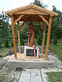
Szent Borbála statue

Miners Memorial

Drill shield for coal mining

Tram


.JPG)
.JPG)
.JPG)
.JPG)
literature
- A farkaslyuki szénbányászat 100 évéről (1914-2014). Edited by Farkaslyuk község Önkormányzata, Eger 2014, ISBN 978-963-08-8594-2 .
Web links
- Official website (Hungarian)