
Bánréve
| Bánréve | |||||
|
|||||
| Basic data | |||||
|---|---|---|---|---|---|
| State : | Hungary | ||||
| Region : | Northern Hungary | ||||
| County : | Borsod-Abaúj-Zemplén | ||||
| Small area until December 31, 2012 : | Ózd | ||||
| District since 1.1.2013 : | Putnok | ||||
| Coordinates : | 48 ° 18 ' N , 20 ° 21' E | ||||
| Height : | 153 m | ||||
| Area : | 6.62 km² | ||||
| Residents : | 1,302 (Jan 1, 2011) | ||||
| Population density : | 197 inhabitants per km² | ||||
| Telephone code : | (+36) 48 | ||||
| Postal code : | 3654 | ||||
| KSH kódja: | 21953 | ||||
| Structure and administration (status: 2018) | |||||
| Community type : | local community | ||||
| Mayor : | Gábor József Hajdu (independent) | ||||
| Postal address : | Kossuth Lajos u. 24 3654 Bánréve |
||||
| (Source: A Magyar Köztársaság helységnévkönyve 2011. január 1st at Központi statisztikai hivatal ) | |||||


Bánréve is a Hungarian community in the county Putnok in Borsod-Abaúj-Zemplén .
Geographical location
Bánréve is located in northern Hungary , 40 kilometers northwest of the Miskolc county seat , right on the border with Slovakia . Neighboring communities are Hét (4 km), Sajópüspöki (5 km) and Serényfalva (3 km) and Lenartovce (Slovakia). The nearest town, Putnok, is five kilometers east of Bánréve.
Parish partnership
-
 Rimavská Seč (Slovakia)
Attractions
- Reformed Church, built in 1926
- Magyarok Nagyasszonya Roman Catholic Church , built in 1928
- Vay-Serényi-kastély
traffic
Main road no.25 runs through Bánréve . The main road 26 leads in a northerly direction to the Slovak municipality of Kráľ , a country road in a western direction to the Slovak municipality of Lenartovce. The municipality is connected to the railway line from Ózd to Miskolc . Bánréve also has a border station with Slovakia. However, passenger traffic on the route to Slovakia was discontinued in 2009 and only goods have been transported since then. Two kilometers south-east of the town center there is the Bánrévei Vízmű stop , which is located directly on the Sajó River .
photos
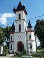
Roman Catholic Magyarok Nagyasszonya Church

Main altar of the Roman Catholic church
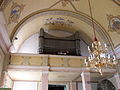
Organ in the Roman Catholic church

reformed Church

Stork's nest in Bánréve


Web links
- Bánréve ( Hungarian )
- A bánrévei református templom. Tiszáninneni Református Egyházkerület, accessed October 26, 2013 (Hungarian).