
Fischbach (Saar)
| Fischbach | ||
 Fischbach southwest of Fischbach |
||
| Data | ||
| Water code | DE : 26436 | |
| location | Germany | |
| River system | Rhine | |
| Drain over | Saar → Moselle → Rhine → North Sea | |
| source | at Merchweiler 49 ° 21 '3 " N , 7 ° 3' 58" E |
|
| Source height | approx. 312 m above sea level NHN | |
| muzzle | in Saarbrücken in the Saar coordinates: 49 ° 14 '14 " N , 6 ° 58' 55" E 49 ° 14 '14 " N , 6 ° 58' 55" E |
|
| Mouth height | approx. 190 m above sea level NHN | |
| Height difference | approx. 122 m | |
| Bottom slope | approx. 7.1 ‰ | |
| length | approx. 17.2 km | |
| Catchment area | 55.3 km² | |
| Left tributaries | Jungewaldbach, Trenkelbach, Heiliggraben, Rennborn, Johannes Böschbach, Fernmeldegraben, Blochersbergbach, Hirschwiesgraben, Heiligengraben | |
| Right tributaries | Weiherchenbach, Heinzenwiesbach, Kohlbach, Lasbach, Hölzerbach, Dahlbach, Bornhomms, Birkhommes, Dörnhassler Bach, Forstbach, Netzbach, Pfalzhausbach, Neuhausbach, Steinbach , Dörrbrücherbach | |
| Big cities | Saarbrücken | |
| Communities | Quiver | |
The Fischbach is an approximately 17.2 km long, northern and orographically right tributary of the Saar in the Saarland district of Neunkirchen and Saarbrücken regional association and in the Saarland capital Saarbrücken .
geography
course
The Fischbach rises in the district of Neunkirchen in the Saar coal forest , which it mainly drains. Its source is on the southern edge of the core town of Merchweiler, directly west of the Fischbachtalbahn, which largely accompanies the flowing water . The stream flows as a main waters in Fischbachtal in predominantly southsouthwest direction. First, he runs approximately along the eastern edge of the main location of the municipality Quierschied where cabbage and Lasbach open out, and after inflow of the timber Bach through the district Fischbach , where it will flow to the Dahl stream. After this, the Fischbach is first fed by the Netzbach and a little later by the Steinbach . From the built-up area of Rußhütte , a district of the independent city of Saarbrücken , the stream flows southwards until it finally flows into the Saar at the Saarbrücken public park a few meters west of the Westspange after leaving the Fischbachtalbahn .
The Fischbach is piped at its source in Merchweiler and before its mouth in Saarbrücken .
- The Fischbach from the source to the mouth

Fischbach at the origin in Merchweiler
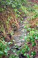
Fischbach in Merchweiler
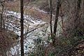
Inflow of the Netzbach into the Fischbach
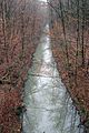
Fischbach near the former Fischbachbad

Fischbach in Saarbrücken-Russhütte

The Fischbach flows into the Saar in Saarbrücken


Course of the Fischbach at the mouth in the course of history
In the 1860s, the Saarkohlenhafen was created in the area of the mouth of the Fischbach from a Saar arch and the Saar straightened. From this time on, the Fischbach did not flow directly into the Saar, but into the harbor basin. When the Saarkohlenhafen was abandoned in the 1960s and the port basin was backfilled, the course of the Fischbach had to be extended by approx. 250 m in order to divert it back into the Saar.
- The mouth of the Fischbach in the course of time

The mouth of the Fischbach before the construction of the Saarkohlenhafen and the straightening of the Saar

Mouth of the Fischbach in the port basin of the Saarkohlenhafen
Mouth of the Fischbach today


Localities
- Merchweiler
- Quiver
- Fischbach (district of Quiigart)
- Saarbrücken
Water quality
The upper course of the Fischbach up to the entrance to Fischbach is assigned to quality class II-III (critically polluted). In the middle and lower reaches of the Fischbach is considered to be heavily polluted (quality class III-IV).
Trivia
In the 1920s and 1930s the brook flowed through the Fischbachbad .
Web links
Individual evidence
- ↑ a b GPS Outdoor , on gpso.de
- ↑ a b c Saarland Statistical Yearbook 2014 , on destatis.de (PDF; 1.6 MB)
- ↑ Water quality 2008 , published by the Ministry for the Environment, Saarbrücken 2009, accessed on July 21, 2016, on saardok.sulb.uni-saarland.de (SaarDok), the archive server of the Saarland University and State Library (PDF; 8.8 MB)