
Fischbach (Seckach)
| Fischbach | ||
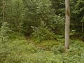
 The brook in the lower Fischbachtal |
||
| Data | ||
| Water code | DE : 238868 | |
| location |
Building land
|
|
| River system | Rhine | |
| Drain over | Seckach → Jagst → Neckar → Rhine → North Sea | |
| source | at Waidachshof in the municipality of Seckach in the Neckar-Odenwald district 49 ° 25 ′ 9 ″ N , 9 ° 19 ′ 44 ″ E |
|
| Source height | approx. 301 m above sea level NN | |
| muzzle | at the valley mill below Sennfeld, City of Adelsheim Coordinates: 49 ° 22 '38 " N , 9 ° 22' 9" E 49 ° 22 '38 " N , 9 ° 22' 9" E |
|
| Mouth height | approx. 208 m above sea level NN | |
| Height difference | approx. 93 m | |
| Bottom slope | approx. 13 ‰ | |
| length | 7.4 km | |
| Catchment area | 15.118 km² | |
| Communities | Seckach , Schefflenz , Adelsheim | |
The Fischbach is over seven kilometers long, right and northwestern tributary of the lower Seckach after the Adelsheimer village Sennfeld in the Neckar-Odenwald-Kreis in northern Baden-Württemberg .
geography
course
The LUBW river map shows that the Fischbach begins at the north-western tip of the birch forest about one kilometer west of the Seckacher Waidachhof . This view should by no means be undisputed, as a whole cluster of only temporarily water-bearing ditches runs around the Waidachshof and none of them is a fully developed stream. At the Schmachtelberg farm (town of Adelsheim ), the Mossiggraben, the last of this cluster, flows at this point immediately north of the federal highway 292 , which cuts through the catchment area in an east-west direction. For the 4.0 km of the Unterlauf still following, the designation as Fischbach is undisputed. This is where the Fischbachtal begins morphologically, which deepens more and more towards the southeast towards the Seckachtal and initially flows through the large Weidach forest on its eastern edge. The water donation from this makes the Fischbach a permanently water-bearing, handsome, clear and clean forest stream. While initially there is forest in the creek blade, the narrow meadows of the Hebstetter meadows line the course of the creek on its lower half . Finally, the valley opens up to the Seckachtal, here lies the half-hectare-sized Fischbachsee next to the flowing water , which offers a picturesque picture with its small island, which can be reached via a wooden walkway from the north bank. Below the last houses in Sennfeld, a district of Adelsheim, the Fischbach flows into the Seckach at the Talmühle .
The Fischbach, if only counted from the B 292, runs entirely in the area of the city of Adelsheim . The north-western upper course, which LUBW ascribes to it, is followed for a long time by the municipality boundary between the municipality of Seckach in the northeast and Schefflenz in the southwest, the latter also includes the majority of the Weidach, while most of the northern ditch tributaries are still in the Seckach area.
Tributaries
Hierarchical list of the tributaries, each from the source to the mouth. Selection.
-
Moosiggraben ( left ), 1.8 miles
- (Bach from the Haintalklinge ) ( left ), 1.6 km
- Heuscheuerlegraben ( left ), 0.4 miles
- (Bach aus der Eichklinge ) ( left ), 1.2 km
Landscape character

For the landscape surrounding the Fischbach there is a threefold structure.
- The uppermost part of its catchment area up to the entry of the Fischbach into the Weidach is predominantly characterized by intensive agricultural use. The stream bed and the trenches that flow towards it are usually straightened and often free of wood.
- In the middle section, where the Fischbach flows through the Weidach and its valley deepens, it is a pure forest stream. The forestry use is comparatively intensive. Large parts of its valley are planted with unstable softwood stocks, the proportion of which is obviously declining.
- Without taking up any noteworthy tributaries, the Fischbach has a significantly higher water flow in its lower section; water may be leaking from the streambed itself. A connection with the entry of the stream bed into the middle Muschelkalk, a layer that carries groundwater in this area, is likely (cf. Sulzbach , Hergstbach ). About two kilometers before the Fischbachtal opens to the Seckachtal, the Fischbach leaves the forest here, whereby the woodland slowly thins out and initially only narrow meadows accompany the stream. This is where the lowest section of the valley begins, which has an extremely lovely and idyllic character and which is of certain importance as a local recreation area. The grassland on both sides of the woody stream widens somewhat, while the slopes are still made up of forest - almost exclusively mixed deciduous forest. The brook itself has formed countless small natural weirs and falls through sintered lime , between which there are often small islets.
Protected areas
Large parts of the valley were designated as a Fischbachtal landscape protection area by ordinance of the Buchen District Office of 12 June 1956 . The LSG has the protected area number 2.25.015 and is around 55 hectares in size. The lower valley section outside the forest is part of the FFH area Seckach and tributaries . Parts of the hillside forest in the lower Fischbachtal are designated as forest protection areas ( Schonwald ). In addition, several legally protected biotopes are mapped in the Fischbachtal (so-called §32 biotopes according to § 32 State Nature Conservation Act).
At the lower beginning of the Fischbach Valley, near the Fischbachsee, a sign shows the following inscription, which is not entirely correct:
Fischbachtal nature reserve
Much glorious in the world
Has melted away in war and strife
Who protects and sustains
Has won the most beautiful lot.
Sennfeld mayor's office
The N 292 Oberschefflenz – Adelsheim accompanies the Fischbach on the right side at a small distance on most of the not yet deeply deepened upper course up to the inflow of the Moosiggraben . In the lower valley, which begins afterwards, there are only farm roads. The valley is suitable for gentle forms of relaxation such as hiking . It goes without saying that the existing legal norms must be observed (Federal Nature Conservation Act, State Nature Conservation Act, LSG Ordinance, etc.)
More pictures

In the lower section of the Fischbach valley
The Fischbach on its way through the Weidach


swell
Ordinance on the Fischbachtal landscape protection area of June 12, 1956
- Central map server of the LUBW
- Leisure map 1: 50000 - F 514 Mosbach. State Surveying Office Baden-Württemberg, Stuttgart 2006
- Topographic map 1: 25000 - sheet 6622 Möckmühl. State Surveying Office Baden-Württemberg, Stuttgart 2006
References and comments
- ↑ Josef Schmithüsen : Geographical land survey: The natural space units on sheet 161 Karlsruhe. Federal Institute for Regional Studies, Bad Godesberg 1952. → Online map (PDF; 5.1 MB)
- ↑ Wolf-Dieter Sick : Geographical land survey: The natural space units on sheet 162 Rothenburg o. D. Deaf. Federal Institute for Regional Studies, Bad Godesberg 1962. → Online map (PDF; 4.7 MB)
- ↑ Reading on TK25
- ↑ a b c d e f State Institute for the Environment Baden-Württemberg (LUBW) ( notes )
- ↑ The designation as NSG is incorrect.