
Hergstbach
| Hergstbach | ||
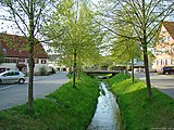
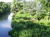
 The Hergstbach in Ruchsen |
||
| Data | ||
| Water code | DE : 238854 | |
| location |
Building land
|
|
| River system | Rhine | |
| Drain over | Jagst → Neckar → Rhine → North Sea | |
| origin | The confluence of the right Hergstgraben and the left Heidelsgraben in Leibenstadt 49 ° 22 ′ 9 ″ N , 9 ° 25 ′ 1 ″ E |
|
| Source height | approx. 270 m above sea level NHN | |
| muzzle | at Ruchsen from the right and finally east into the Jagst coordinates: 49 ° 19 ′ 9 ″ N , 9 ° 22 ′ 32 ″ E 49 ° 19 ′ 9 ″ N , 9 ° 22 ′ 32 ″ E |
|
| Mouth height | 176 m above sea level NHN | |
| Height difference | approx. 94 m | |
| Bottom slope | approx. 6.4 ‰ | |
| length | 14.7 km with Hergstgraben | |
| Catchment area | 32.461 km² | |
| Small towns | Osterburken , Adelsheim , Möckmühl | |
The Hergstbach is an almost 15 kilometer long stream in the north of Baden-Württemberg in the Neckar-Odenwald district and in the Heilbronn district , which runs into the Möckmühl suburb of Ruchsen from the north and to the right of the Jagst .
geography
The actual Hergstbach from Leibenstadt is almost nine kilometers long, if you follow the course of the Hergstgraben to the sources near Hergenstadt , you come to a length of about 13 kilometers, with the entire right upper reaches of Hergstgraben, which begins in Marienstadt, of 14.7 km. Its catchment area is bounded in the east by the Kessach and in the west by the Seckach and covers 32.5 km², with which the Hergstbach ranks tenth among the tributaries of the Jagst. Measured by this, however, its water flow is remarkably low. Nevertheless, it can reach a depth of up to 1.3 meters in normal water.
Hergstgraben and Heidelsgraben
The Hergstbach arises in Leibenstadt from the confluence of the right Hergstgraben and the left Heidelsgraben, which are almost the same size and length and run roughly parallel.
The search for the origin of the Hergstbach does not provide a clear result. A source is not defined. There are some unproductive springs northeast of Hergenstadt (town of Adelsheim ) at an altitude of about 350 meters, another spring is in Hergenstadt itself. From there the Hergstgraben begins its course in south to south-west directions. The water it carries here, however, is mainly surface water; the flow of water quickly succumbs here, so there can be no question of a constant spring. The depressions of the beginning Hergstbach valley extend to the hamlet Marienhöhe (town of Osterburken ).
The valley of the Heidelsgraben initially harbors a small river, the Hundel . This seeps away after a short run. Hopfengarten, part of the community of Schöntal in the Hohenlohe district, is located near the Hundel . Only further down the valley is the ditch called Heidelsgraben. At the level of the sports facilities of SV Leibenstadt, it unites with the Hergstgraben.

The Hergstgraben

The dogs before they drained away

Hergstgraben (left) and Heidelsgraben create the Hergstbach here. A side ditch, however, already above Leibenstadt leads to water from the Hergstgraben to the Heidelsgraben.


River course
From its origins to the confluence with the Jagst , the Hergstbach flows almost exclusively in southern to southwestern directions. Below Leibenstadt, the stream lined with willows and alders changes into its still flat and gentle valley in Möckmühler municipality area and soon afterwards flows through Korb . About one kilometer below Korb, the very short Heilbronner Graben flows in from the left , and only a few meters downstream the slightly larger Bärbach flows from the right . Both only have some water for a few months a year. Various other ditches and gorges periodically contribute to the feeding of the Hergstbach. The Hergstbach is partially straightened between Leibenstadt and the Bärbach estuary.
The further you follow the stream downstream, the more clearly the appearance of the valley changes, which digs deeper and narrower into the shell limestone and winds ever stronger. There is no longer any space here for settlements. In this section, the Hergstbach has even created a small rock face about eight meters high. Its south-facing slopes were partially used for viticulture in the past and now form valuable biotopes. The narrow floodplains are partly used for agriculture. A small road connects Korb mit Ruchsen , from which the access to the hamlet of Dippach branches off between the villages, which is a flatter point on the slope. The Hergstbach finally reaches Ruchsen and thus the valley of the Jagst , in which it is at an altitude of about 176 m above sea level. NN flows.
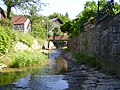
The Hergstbach in Korb
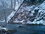
Scene at the Hergstbach near Dippach
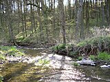
In the lower Hergstbachtal
Little glue on the Hergstbach

The Hergstbachtal near Korb

In the lower Hergstbachtal. The stream bed of the Hergstbach appears disproportionately wide in many places.

When entering Ruchsen, the Hergstbachtal opens up to the Jagsttal.

Hergstbach with meadowsweet on the last few meters of his way
Estuary of the Hergstbach into the Jagst (2008)

Hergstbach estuary (2009, after surgery)


Tributaries
Tributaries of the Hergstbach from the confluence of Hergstgraben and Heidelsgraben to the mouth. Selection. Inflows still insufficient, little available to EZG
- Klingengraben ( right ), 1.9 km
- (Bach from the Märzengrund ) ( right ), 0.5 km
- (Bach aus der Fuchsklinge ) ( right ), 1.4 km
- Heilbronner Graben ( left )
- Bärbach ( right ), 1.7 km
Places on the Hergstbach
- Hergenstadt (on the Hergstgraben)
- Leibenstadt
- basket
- Dippach
- Ruchs
Water flow of the Hergstbach
Although the Hergstbach is the tenth largest tributary of the Jagst in terms of its catchment area, it carries very little water compared to other rivers that are comparable in terms of catchment area and climate, for both natural and man-made causes.
Most of the Hergstbach lies in the Muschelkalk, a karst rock in which it often seeps away, and apparently loses considerable amounts of water to its subsoil. Its bed is higher than that of the neighboring, more powerful brooks Kessach and Seckach; it is thus in a similarly disadvantageous position as the Jagst compared to its competitors (see there), which, however, unlike the Hergstbach, also has some sections with more water.
In the Hergstbach area - as is generally the case in the southern building land - Keuper is only present in thin remnants, often overlaid with loess clay, which lie on the plateaus. The upper shell limestone is strongly karstified and therefore very permeable to water. The middle Muschelkalk, a saline rock, could be considered as an aquifer, but it is very depleted and releases most of the groundwater to deeper layers. The lower Muschelkalk is less karstified and takes on the function of an aquifer. The stream bed of the Hergstbach runs entirely in the upper Muschelkalk, while the nearby riverbeds of Seckach, Kessach and Jagst are mainly in the middle Muschelkalk. Although the Hergstbach falls quite sharply to the south, it does not reach the middle Muschelkalk as far as its mouth in Ruchsen, as the rock layers drop to the south. The lower Muschelkalk - the most important aquifer in this area - is therefore deeper than the Hergstbach stream bed. So only a little groundwater finds its way into the Hergstbach, while most of it reaches other catchment areas.
Another circumstance is the land consolidation, in the course of which soils around the Hergstbach were drained in many places and therefore the soil now stores less water, the water flows off faster on the surface and the runoff is concentrated on a few and particularly strong floods. According to local residents, the usual water flow was actually greater before the land consolidation.
The stream bed of the Hergstbach is disproportionately wide for the typical flow. Especially in the summer months, it regularly falls so sharply that the Korber sewage treatment plant ultimately becomes the most important inflow. Because the Hergstbach is above this sewage treatment plant much earlier and longer dry than below, but also below it its water flow sometimes completely dries up, so that then only a chain of pools and puddles remains. However, this is unlikely to have any impact on the average water flow, as it is not the total annual runoff that changes, only its distribution over the year.

Hergstbach with the lowest water flow

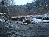
Minor floods after melting snow (2008)
Ruchs. The bridge in the background was demolished in December 1993

Water flow in September in the lower Hergstbachtal

Hergstbach at the mouth of the river with floods. The more strongly colored Hergstbach water can still be seen a few meters after the confluence (December 2009).

Estuary during a slight flood on February 25, 2010


If you look at the modest Hergstbach with normal water flow or even in midsummer, it is difficult to believe how powerful the brook can swell at high water. In December 1993 it flooded the lower-lying parts of Ruchsens, at a crossroads the water flowed one and a half meters above the street. Korb is also regularly hit by floods. Efforts have long been made to get the city of Möckmühl to take protective measures against it. The very rapid rise in the water level, which is natural in small bodies of water, is dangerous, but in the case of the Hergstbach - as with countless other brooks in agricultural areas - it is mainly due to the fact that the agricultural areas are often drained and the fields are regularly traversed by drainage channels, so that the ditches on dirt roads are meticulously cleaned and often no hedges or woodlands are allowed to emerge. One seems to want to drain the rainwater as quickly as possible - literally according to the saying “after us the deluge”.
The floods in Korb are only partly due to the Hergstbach, because it rarely reaches such a high water flow that it would step out of its artificial bed here. More often the water comes from an inconspicuous side valley, the fox hole . The ditch leading from there is trapped in the village area with a pipe that is too narrow and almost level. If the Hergstbach is now high, it blocks the drain from the Fuchsenloch . If, after heavy rain or prolonged rainfall, large amounts of water tumble down the side valley on the water-saturated soil, they look for an above-ground path - which can only lead across the streets and of course does not stop in front of buildings.
Landscape, vegetation and wildlife
The Hergstbachtal, especially its lower section, is important from the point of view of nature conservation , landscape maintenance and recreation . This area is extraordinarily rich and structured on a small scale, houses an abundance of special biotopes with a corresponding biodiversity and the valley is relatively undisturbed.
It is characterized above all by the diversity and the mosaic-like alternation of near-natural forest areas, hedges and bushes, meadows and floodplain biotopes, which are home to a certain abundance of numerous rare or protected plant species. These include, for example, golden thistle , pasqueflower , columbines , field quail wheat , branched grass lily , bee ragwort , helmet orchid , purple orchid or the fringed gentian . On former vineyard sites there are partly orchards, of which due to lack of care, they are in different stages of succession . On some areas, old forms of land use (extensive use of grassland, viticulture or fruit growing on orchards) are imitated by maintenance measures in order to preserve the corresponding biotopes. This mainly affects areas on the steep slopes, but only a minority; the majority of the impact slopes will be managed in the long term, where this has not already happened.
The Hergstbach is poor in fish due to extreme water level fluctuations (see above). The rainbow trout , brown trout , minnow , Mühlkoppe and loaches are proven .
At the Hergstbach it is possible to encounter the kingfisher , but it can be assumed that it is only a guest here.
The general game trail plan for Baden-Württemberg, drawn up by the Forestry Research and Research Institute of Baden-Württemberg, provides that a game corridor of national importance should run through the lower Hergstbachtal. The corresponding axis connects the Swabian-Franconian Forest via the forests of the Hohenlohe Plain , the Harthäuser Forest and the Weidach with the eastern Odenwald . The route crosses the Jagsttal between Ruchsen and Widdern and leads through the lower Hergstbachtal and the Möckmühler Weg forest near Hagenbach into the Altes Bannholz forest before it crosses the Seckachtal between Roigheim and Sennfeld. According to this concept, the Hergstbachtal would also be of great formal importance from the perspective of the biotope network .
360 hectares over the largest part of the Hergstbachtales extending the conservation area Hergstbachtal . There is also the 3.8 hectare nature reserve Weinberg im Hergstbachtal , a species-rich semi-dry grass slope , an oak as a single natural monument and the extensive natural monuments in the lower valley , Steppenheide Bachwingert , Vordere Weinsbergäcker and Steppenheide Untere Steig . The latter, although very close to Ruchsen, belongs to the city of Aries . More information about the protected areas can be found on the LUBW website , see sources.

Well-maintained steep slope in the lower Hergstbachtal (FND "Steppenheide Bachwingert")

Forested vineyards in the lower Hergstbachtal

Pasque Flower Pulsatilla cf. vulgaris in the extensive natural monument "Steppenheide Untere Steig" on the ridge between Jagst- and Hergstbachtal

Knabenkraut ( Orchis militaris ) in the FND "Steppenheide Bachwingert" in the lower Hergstbachtal

View of the Hergstbachtal from half the hillside in the FND "Steppenheide Bachwingert"

In May, the semi-arid lawn, which is worth seeing anyway, is littered with thousands of helmwood herbs


leisure
The Hergstbachtal, especially below Korb, is popular for hikes, walks and bike tours due to its scenic charm. The city of Möckmühl would like to expand its cycle path network, there are efforts and plans for a cycle path that should connect to Hergstbachstraße in Korb and lead to Leibenstadt. However, the cycle path collides with landscape and nature conservation interests. The previously planned route runs through a secluded, previously undeveloped section and is located in the Hergstbachtal nature reserve.
history
In the middle of the Hergstbach floodplain, not far from the Bärbach estuary, there is a burial mound, the small Korber Katzenbuckel . The Upper Hergenstadter Forest , in which the sources of the Hergstbach are located, is crossed by the Limes , the course of which is still recognizable today from a straight, wall-like elevation of over a kilometer in the forest.
Apparently the Hergstbach was once called Diebach, at least on the lower section of the river. At least that's what maps from the 16th century call him there. The hamlet of Dippach is also named after this name.
The land consolidations in the seventies as well as the straightening of the Hergstbach and its source rivers had considerable consequences for the landscape of the Hergstbach valley, the ecology and the water balance. For more information, see the paragraph on water flow. But the stream has remained mostly natural or close to nature, especially in the lower Hergstbachtal.
See also
Literature and Sources
- Hans Mattern : The lower Jagsttal. From Dörzbach to the mouth. Baier BPB Verlag, Crailsheim 2005, ISBN 3-929233-27-4 .
- Hans Mattern: On nature conservation trips in northern Württemberg (1 and 2) . In: State Institute for Environmental Protection Baden-Württemberg (Hrsg.): Publications for nature conservation and landscape management in Baden-Württemberg. Volume 67, 1992, pp. 49-96 ISSN 0342-684X (Hergstbach and his valley regarding pp. 66-71).
- Topographical map 1: 25,000 Baden-Württemberg, as single sheet No. 6522 Adelsheim and No. 6622 Möckmühl
- Geological map 1: 25,000 of Baden-Württemberg, sheet no.6622 Möckmühl
- Ruchsen fishing club
- Directory of protected area profiles on the site of the State Institute for the Environment, Measurements and Nature Conservation Baden-Württemberg (LUBW)
- Inquiry to the Ministry of the Environment and response regarding flood protection for Korb from June 27, 2008 (PDF file; 38 kB)
Individual evidence
LUBW
Official online waterway map with a suitable section and the layers used here: Course and catchment area of the Hergstbach
General introduction without default settings and layers: State Institute for the Environment Baden-Württemberg (LUBW) ( notes )
- ↑ Height according to the contour line image on the topographic map background layer .
- ↑ Height according to the blue lettering on the background layer topographic map .
- ↑ a b Length according to the waterway network layer ( AWGN ) .
- ↑ Catchment area summed up from the sub-catchment areas according to the basic catchment area layer (AWGN) .
Other evidence
- ↑ Wolf-Dieter Sick : Geographical land survey: The natural space units on sheet 162 Rothenburg o. D. Deaf. Federal Institute for Regional Studies, Bad Godesberg 1962. → Online map (PDF; 4.7 MB)
- ^ Theo Simon: The history of the Muschelkalkkarst aquifer system in northern Baden-Württemberg. In: Geological Yearbook. Series C, Hydrogeology, Engineering Geology. Issue 66. Schweizerbart, Stuttgart 1999, ISSN 0341-6410 , pp. 47-75
- ↑ Geology according to the geological map listed under → Literature . A rough overview also provides: Mapserver of the State Office for Geology, Raw Materials and Mining (LGRB) ( notes )